Friday 30 March 2018

Australia Tour Update 1: March 8th to April 1st


I am about 3-4 weeks in, and so far, so good, although there has been the odd day of suffering, but that is to be expected.

I set-off from Swan Hill after getting out of Melbourne by train.  I was basically following the Murray river for the first week from East to West, and the main highlight of this first week was the excellent free camping beside the river at numerous locations.  Almost as soon as I left the Murray, free camping has become far less comfortable.


The first few days from Swan Hill to Mildura were made difficult because of the heat.  It was over 30 degrees each day and just after leaving Mildura the mercury shot-up to 37 C.  On that day, I did not plan to cycle much, but at least make it to a free camping spot a little outside of town where I knew I could get a 4G signal , so I could do some work online.  I had spent money on a campsite for the previous two days, and I thought I'd test how working and free camping would work-out.

Some great free-camping along the Murray river.
Well, that was a bit of a nightmare afternoon for a combination of reasons.  I managed to complete the classes, but the stress levels were high.  I started teaching inside the tent, and as uncomfortable as it was, it was doable.  However, as the sun got higher in the sky, the shade of the trees disappeared and it turned into a bit of a sweat-fest.  The more concerning aspect of the heat, however, was the soaring temperature of my computer, which I could have almost cooked my lunch on.  Compounding my problems were ants and flies, meaning that I couldn't open the tent doors and get some breeze blowing through.

Looks nice, but the combination of heat, flies, and ants really made it quite uncomfortable.
All this meant that I had to get out of the tent, but there were very few comfortable places to sit down and the combination of wind and water-skiers made things a little more noisy than ideal sometimes for teaching English.  Going outside did, however, cool the computer down.  It was desperately uncomfortable though because as well as the problem of where to sit, ants, flies, and the sun were all ganging-up on me to make things as difficult as possible.

This was the first of two and a half very testing days, one off the bike, and the rest on it.

The decision to go to a known free-camping area set in motion a disastrous change of route.  I was now out of town to the north of Mildura instead of the south.  I would have had a simple A-road journey of about 140Km to Renmark if I had gone on my intended route, but now I had chosen a more backcountry road.  I knew there might be some areas of unsealed road, but with some good experiences of unsealed roads in Australia on previous tours, it didn't bother me that much.  Indeed, the route looked more interesting and adventurous.

Well, it certainly was adventurous.  Unbeknownst to me, I was entering an area known as the Mallee Wilderness, a particularly barren and isolated area, not very much touched by man, and the state of the roads showed this up nicely.

This bit of random information I found at the end of the road from hell pretty much sums the place up.
I had 150Km to get to Renmark on this route and 110Km of them were on the worst roads I have ever encountered.  If they weren't bumpy, corrugated, or pot-holed, the surface had broken-up so much that in many areas the road simply turned into sand.  I don't know if you have ever tried riding a bike through sand, but suffice to say it is pretty impossible.  Add another 25Kg to your bike and even pushing it while walking becomes crazily difficult.

All this meant that the trip from Renmark was extended by about 8 - 10 hours.  This obviously made me worry a little about water.  Luckily, though, there was at least one pleasant stretch in the middle around Lake Victoria, where the road was sealed for about 10Km and I could fill-up with water.

An oasis in the wilderness, Lake Victoria in the middle of nowhere.
The rest of the way was truly hellish, though, and would without doubt be standing clear at the top of the worst days and a half on a bike I have ever had and, come to think of it, worst days of my life period.  It really was that bad, if you could have followed me with a tape recorder, you might never see me in the same light again, such was the sheer range and rate of shouting and swearing that was going on.  Fortuunately, it was only the kangaroos that had to cover their ears.  Once I had finished, I wished I had taken some pictures of the road, but taking snaps wasn't on my mind at the time.

I'd never want to repeat that day, but strangely enough, I am glad I did it.  When you do something like that, which is truly difficult, truly a test of character, you feel almost invincible for coming through it.  You strut around with the confidence that not even the worst of the Australian outback can get the better of you, and that can be one of the most forbidding environments around.  Many people can't understand why I'd cycle through such a place, but understand that the harshness of the outback is a large part of it's appeal.  Add to that, there was a lot of wildlife on that road, kangaroos and emus everywhere.

To add another nail in the coffin, once the road turned back to bitumen and I could ride fast enough to notice the wind, it was quite severely in my face for the last 15Km into Renmark.  Once I arrived, I ate, ate, and then ate some more, sat down in a nice park and relaxed for a few hours, pulled-out about 10 thorns from my tyres (called Bindis apparently), and repaired a puncture from one of them.

As I sat down, I noticed a sweet little dog sitting about 100 metres away, kind of next to someone, but not really.  After a while it ran over to me and sat by my leg.  He had a collar on, but had no tag and seemed to want some attention.  I asked people around, but they said it wasn't theirs.  With no tag, I called the council, but after a short time he chased a couple of dogs and then ran-off down the street, crossing a busy main road in the process.  Some trampish-looking man said he had seen him doing this all day, and it was lucky he wasn't killed.

I tried to get the dog back but he had gone, sprinting a long way down the road.  I had to inform the council he now wasn't in the park, but heading towards the river.  Ten minutes later, though, and guess who appeared by my leg again!?  I was pretty happy, and this time hooked him up to one of my bungee cords and waited for someone from the council to arrive.  He was apparently reunited with his owner the next day.  As a bit of a dog lover, I was pretty happy with it all.

My office for the afternoon.
Anyway, back to business, and it was now time to make my way towards the Flinders Ranges, with part of the route being very familiar to me.  The route from Morgan to Peterborough was the same as on my Darwin to Melbourne tour 2 years ago just in the reverse direction.  I only repeat two sections on this trip, this one in South Australia, and Katherine to Mataranka in the Northern Territory, which is a few months away.

Everything looked very different at this time of year.  I had gone through this area before in the middle of Winter, and things were much greener.  I stayed in Peterborough in a very nice chap's house I connected with through warmshowers.org.  This was my first time using this website, which lets people make contact with others who are interested in letting cycle tourers stay in their houses, free of charge.  Many even cook meals for their guests, as mine did too (a really fantastic curry, most definitely my best meal of the tour to date).

Sunrise in Peterborough
Chris (yes, his name was also, Chris) was a super-host, even though he was out most of the time working, however he was very easy to get along with and he provided a comfortable, inexpensive place for me to stay for a few days while I worked and rested.

Working while on tour has been a success so far, and in the first three weeks I have managed to cover the expenses of the trip with the work I've done.  I have been using the 4G signal on my phone and hooking it up to the computer.  I have found that the wifi I have been getting in various places is simply not reliable enough for teaching.  Finally, it seems, Telstra is of some use.  Useless in almost every other regard, I can't fault their coverage in Australia and the internet speed.

Another major plus on this tour so far is my new tent.  For such a long trip, and the inevitability of a huge amount of camping, I thought it essential that I was a little more comfortable than on previous tours.  I was worried about the extra weight, but that doesn't seem to be too much of a problem, but the extra room in the tent is absolute bliss and has actually made camping a bit more of a pleasure, rather than just a place to fall asleep every night.

The view at castle point in Hawker after a morning run.
On to the first highlight stop of the tour then, the Flinders Ranges.  After a couple of days working in Hawker, I had a 3-day loop back to Hawker through the iconic hills and mountains, working in some hiking as well.

Over the 2-3 days, I had about 180Km of cycling to do, and I ended-up doing quite an arduous hike up to Mary's Peak, the highest in the Flinders Ranges At about 1150m.  The circuit round, starting from Wilpena visitor's centre, was about 22Km in total, and I did feel it in the hot weather.

At the top of St Mary's peak with the crocodile's back of the ranges disappearing into the distance.
I actually wasn't supposed to go to the top of this peak out of respect for the aboriginal community of the area, but I consider this a silly rule, so I didn't respect it.  I was especially against doing what I was told because of the way I was told not to go by a park official at the visitors centre.  I didn't know about the rule, and just said, "I'm planning to go to Mary's Peak", to which I got the reply of, "No, you aren't".  I had assumed at the time, that the trail was closed, but later found out that it was out of respect.  Well, no one is telling me where I can and can't go, and certainly not in that tone of voice.

The same bloke also gave me some rather unfortunate advice about the state of the bike trail from Wilpena.  The trail was only for mountain bikes, so I had to walk it through most of the way, costing valuable time and energy.  It was, however, super-easy to find a camp spot.

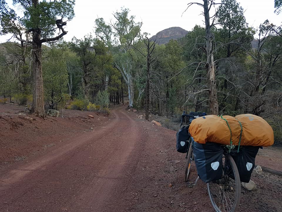
The Mawson Trail was a bit rough for my bike, but it was a bit of an adventure, and nice camping.
The hike was stunning, especially the view from the top, so I was glad I broke the rules, you could see right down the crocodile's back of the Flinders Ranges.  I passed a couple in their late forties who seemed to be struggling with the heat and difficulty of the trail, and from where they were, I couldn't imagine them getting back before dark.  Indeed, that particular trail is closed in the summer months.  Despite it being early Autumn temperatures still rose to over 35 degrees for the few days I was there.

I, half-reluctantly, chose to do some of the back roads around the park and loop back down the Flinders Ranges Way and back to Hawker.  I was a little apprehensive after my trials and tribulations on the dirt tracks earlier on the tour on the way to Renmark.  Bumpy in places, the roads weren't nearly as bad and gave a real feeling of getting away from it all and being lost in the wilderness.

Despite being in the Australian wilderness, I did manage to meet a bloke from Colchester (my hometown in the UK), who was doing a bikepacking tour from Perth to Sydney, going on all the back roads and dirt tracks.

Typically, the first cyclist I meet actually lived in Colchester.
Bikepacking differs from what I am doing, in that it is more a mountain bike set-up designed for backcountry bike trails and it something very appealing to me.  You pack a little lighter and not with panniers, but lots of different little bags and attachments to the bike.  One for the future, I reckon, I'd definitely be interested in doing it.  I'd need a new bike and some different kit though.


I left the ranges the same way I came in, but the weather, the lack of shelter, and the flies were starting to drive me crazy.  I thought I'd take it easy on the penultimate day there and find a nice shaded area and rest for a few hours in the heat of the middle of the day.  However, there was nowhere to get myself out of the sun.  It was so frustrating and when you get tired and frustrated in Australia that's when the flies seem to be at their worst; they land on you once, then again, and again, and again.

Look closely.  Under almost every tree that could offer shade sat a bunch of kangaroos.
The Flinders Ranges had more kangaroos, wallabies, and emus than I had ever seen anywhere else, amazing for such a harsh landscape and climate.  I started to admire their ability to survive while I suffered-away in the heat with limited supplies of water.  The kangaroos would either be bouncing along the side of the road, often quite close to me while riding, or chilling-out under trees.  When you looked closely into the distance, you could see just how many of them were around just sitting under trees in the middle of the day.


Another problem I had was that because of the high temperatures and lack of shade I was getting through a lot of water.  I also lost a bottle because I filled-up at a rainwater collection spot only to discover the water was putrid, which stained my bottle with the most vomit-inducing odour imaginable.  All this meant that after I stopped to camp, about 25 Km from Hawker, I ran out of water and then just had to cycle into town in the middle of the night as sleep was impossible.  When you get truly dehydrated you fantasize about drinking, jumping into swimming pools, singing in the rain, and all that, it's quite something.

After a day's rest in Hawker and some work I was back on the road again, this time heading south towards Port Lincoln.  This was a stretch of the tour I wasn't looking forward to much because of the high chance of headwinds and the mostly uneventful roads with few attractions.  I met another cyclist, this time a girl from Slovenia, who was travelling from Perth to Sydney.  Her tribulations with the wind had been much greater than mine, though, as she crossed the Nullarbor from the wrong direction at this time of year, and bore the full force of the notorious winds in this area of Australia.

Natalie from Slovenia, had already crossed the Nullarbor into the wind most of the time.  Top effort, that is not for the faint-hearted, even with the wind.
I managed to get in a workout in a gym and a game of squash in Port Augusta - my second game of the tour, I also managed one in Mildura.  After 80Km of riding in the morning, I hit the weights and then a few games of squash.  It was nice to get the body doing something else except cycling.  I was obviously pretty slow on court, but I haven't dropped a game yet.  This may change in Perth where I will face stiffer competition, I'm sure.

After Port Augusta it was as I feared, a bit of a slog into the wind, but the wind didn't blow too badly, and I got most the distance I needed to cover daily done very early in the morning, before it got too strong.

View from the lookout in Whyalla.
I had a difficult day coming into Whyalla, an industrial town on the coast of the Eyre Peninsula.  I was a bit tired and fed-up, but I thought I'd struggle-up to a lookout and eat some lunch.  Whilst looking out over the marina, I noticed a fishing boat returning, and following were a number of dolphins.  I jumped on the bike to see if I could get a closer view, and sure enough they came right up to the jetty and hung around waiting for some fish and eyeing us up at the same time.  I have never seen dolphins up so close, it was amazing.  It was pretty awesome to actually look into their eyes and it made me look at them slightly differently, it really seemed like there was a lot going on inside their heads.  There were 8 dolphins in all, 4 mums and 4 calves; the mothers were the only ones to eye us up and stick their heads out of the water.


Mum and calf.  The calves almost seemed like little toys, very cute.
It really was a huge lift, as I am very much a nature person, unlike my dad (private joke).  I had a bit more of a rest afterwards and I was motivated and raring to go later in the day.

One of the fishermen kindly gave me a fish to feed one of the dolphins; she was very gentle.
The next few days were just a grind into the wind and wild camping, which was a bit easier than I had imagined, but it still drains you after a few days.  I was dirty, tired, and in need of a rest.  Fortunately, Port Lincoln came just in time and I settled-down with my new warmshowers hosts, Peter and Lana, which is where I will pick up from next time.


Sunday 18 March 2018

California Winter Wonderland - Part 2

A view from the top of Eagle Point over the high Sierra Nevada mountains with half dome in view.
From looking at the pictures from part 1, you'd be forgiven for thinking that Winter really isn't Winter in California, but I can assure you that it was cold at night, right from the start of the tour.  That being said, the days were warm and sunny, and California hadn't really had much of a Winter until I arrived, but that was set to change.

Perhaps you can understand why I didn't cycle up there.
As I entered the second week, I did notice that things were turning decidedly colder, just at the wrong time really as I was headed into the mountains.  Just prior to setting up camp at Horsecreek campground (at the end of part 1), I had discovered that my intended route through the mountains was all closed-off.  To make matters worse, even the road up to General Sherman and the giant sequoia groves in Sequoia National Park was closed on the morning I was intending to go there due to heavy snow.


Luckily, however, the road did open, but it would have been suicide to cycle up there, so a change of plan was required.  I met a chap from North Carolina in the campsite who wanted to go up also, but was concerned about the cost of hiring snow chains - which were definitely required - plus the park entrance fee.  We agreed to share the ride and the cost, and then luckily we were joined by a Texan who also wanted to go and cut costs at the same time.  Expenses divided then, we were set to go and I was very glad I made it up there.  It really was quite an experience to see those immense trees, and the snow made it even more spectacular.

That is one big tree!
The closed roads meant that I had some thinking to do.  I could only really pick my way through the towns and cities in the San Joaquin Valley for 200Km or so to Merced and then onto Yosemite for what promised to be the most awesome place on an already terrific tour.  I thought better of it, especially as some of these cities didn't have the best reputations.  I had some Amtrak ticket vouchers from my canceled original trip, so I thought I'd use them and take it easy for a day.

Arriving in Yosemite Valley
From Merced there was the small matter of about 140Km to get up to Yosemite National Park.  I had timed things well, I made it to a hostel, just a few kilometres shy of Yosemite before another round of heavy snow came in overnight.  I spent the night in the hostel and the next day, waiting-out the worst of the snow.  I also really appreciated the rest.  I had camped every single night for 8-straight nights in progressively colder weather.

The roads were too bad to cycle in the last few kilometres, so I took the shuttle bus into Yosemite Valley, and luckily they accepted bikes.  Once there, I set up camp and began to explore the park.  It was pretty incredible, and also a bit weird being surrounded by huge granite walls everywhere.

Yosemite falls, the highest in North America, apparently.
I wondered around the lower part of the valley on the first day, catching great views of half dome and Yosemite falls.  I settled-down to camp that first night in the genuine cold.  Overnight, the temperature got down to - 8 degrees Celsius.  I felt a little cold back at the Horsecreek campground when it was - 5 C, so I prepared in advance and borrowed a blanket from the hostel for a more comfortable night and it worked marvelously.  As long as I was in my tent, I was fine, and in fact, got a great night's sleep, despite the risk of bears also.  All my food was safely away in the bear lockers, so that I didn't have any unwanted visitors sniffing around in the night.


When I woke up in the morning I knew I wanted to head up to the top of something and get a view from above, but I wasn't really sure where I was going other than to the top of Yosemite Falls.  Once I had made it up there, after a steep climb, I was joined by a chap from Washington who said he aimed to get to the top of El Capitan on the day.  That was a long hike, especially in thick snow, but because there was two of us, I felt compelled to join him.

Near the top of the waterfall, mostly frozen.  Occasionally snow and ice would break off causing a roaring sound to bounce off the walls of the valley.  It made for a fantastic atmosphere.
Once past Yosemite falls, it was clear that not many people had gone any further.  The snow was deep and we followed some footprints towards the turn-off for Eagle Point, the highest peak in the area.  Once we past this intersection to go to the top of El Capitan, however, the footprints disappeared and the trail disappeared beneath the snow.  We decided to trudge on, partly because there was two of us, the weather was good, and if in doubt we could always follow our footprints back to where we knew the trail was for sure.

It was difficult, and we set ourselves a time limit to get to El Capitan, or else we'd just have to turn back.  It was quite an adventure using contours on our map and a little bit of experience to try and trace where the trail should be.  In the fresh snow, we could also see what wildlife had been before us; deer, rabbits, bobcats, and more worryingly, huge bear prints.  Just as well there were two of us.


Turns out, though, that we didn't make it, it was just too slow-going in the snow and it took time to make sure we were on course, so we headed back to the intersection of the trail and where it lead off to Eagle Point.  The view up there certainly didn't disappoint, with the most gorgeous of vistas over the high Sierra Nevada mountains, awe-inspiring stuff.

The next day, I wanted to get a good look at El Capitan - a sheer face of rock famous for people climbing it - and get a view of the whole valley, which I had to do a bit of a detour to on the way out of the park later on.


I went for a short walk first thing in the morning, but before I set-off, a bunch of stoned fellow campers took time to shake my hand and tell me what a bad ass I was for cycling and camping in the wintry weather.  Marijuana had only just been legalised in California - about a week before I arrived - and I even got to sample some in cookie form the day before while I was hiking.  A very small cookie that packed a pleasant punch that kicked-in after about an hour and a half.  It was very nice of my hiking companion to offer me one and it did make for a humorous end to the day.


Anyway, it was a pleasant morning hike in very still, cold, but nice weather, affording excellent views down the valley and eventually the sheer face of El Capitan.


After the hike, I packed-up my things and left on the bike, but not before taking a detour to the famous "Tunnel View" of the valley.  It was probably a 10-15Km trip out of my way, but it was worth it, a view encapsulating much of the famous landmarks of the valley, and on another beautiful day, it was picture perfect.

The view without me spoiling it.
Yosemite was as awesome as it promised to be, and I had only to make it back to Merced for the end of my cycling on the trip.  From Merced, I took the Amtrak to avoid picking my way through all the cities in the very populated part of northern California.  First though, I spent another night in the same hostel to relax in the warmth and to return the blanket I had borrowed.

Sadly, on the way out of the stunning Yosemite valley.
I only had a couple of train rides amounting to about 4 hours once back in Merced, and then I had a couple of days back in San Francisco to relax, explore the city a bit and prepare the bike for the trip back to Melbourne.

I enjoyed San Francisco as a city, though I don't think I'd want to live there.  When I got back to Melbourne, I appreciated what a nice city it really is to live in.  The environment was better, it was a lot more relaxed, and it felt a lot safer.  San Francisco was an interesting place to visit, with lots of interesting sights and things to do, and even the homeless people - of which there were a lot - were kind of mildly entertaining, in a bit of a troubling way, as most of them were absolutely crazy, seeming to have a real issue with mental illness.


Perhaps it says something about my character that the first thing I wanted to see upon getting back to San Francisco was the sea lion colony that had made it's home on one of the piers in the harbour.  They really were extraordinary, probably about 150 sleeping, fighting, swimming, scratching, and yelling at each other with the backdrop of the golden gate bridge in the background.


Ironically, the weather on the day I left was the only cloudy day of the trip (it snowed on a couple of nights, but the days were always sunny).  But I still went to the Twin Peaks to get a look at the whole city.  On my way back I sorted-out a box for the bike and packed everything away. 

The city from "Twin Peaks".
It was a sensational trip, and I managed to fit a lot into two weeks; an extraordinary coastline, the biggest trees in the world, an iconic city, and some of the most unique and spectacular mountain scenery you could ever see.  Now in Australia, each day doesn't pack the same punch, but all tours have their unique qualities and touring around Australia will be an amazing experience.  Stay tuned for updates.


Friday 9 March 2018

California Winter Wonderland part 1


Another successful trip completed, but another one immediately under way.  I am finishing this post while on the road in Australia, but looking back on a spectacular 2-week tour of Northern California.  Again, this one had some adjustments to the original plan, but that didn't take anything away from how spectacular it was.  Probably my most unique and educational trip so far.

The first part of the trip.

I started and finished in San Francisco, beginning with just over 300Km of riding down the Pacific coast, which was the best riding of the trip.  An absolutely stunning coastline, and I was fortunate enough to have a gentle tailwind most of the way.


 There were plenty of scenic views all the way down, but the area around Big Sur was very impressive, with towering cliffs, beautiful beaches, and some of the best riding you are likely to get anywhere in the world.  I also enjoyed the Monterrey Bay area, its pristine coastline harbouring some of the most famous golf courses in the world, as well as some of the biggest mansions I have ever seen.  I took the scenic route through this area in very pleasant weather.


Overnight camping was pretty easy in this section, as there were a number of "Hike and Bike" campgrounds along the coast, which only cost $6.  It was especially nice camping in the Redwoods in Big Sur, but the great views at sunset at the aptly named, "Sunset State Beach", were also very good.


Up until Monterrey, things were a little tricky at times.  I was mainly on highway 1 going South from San Francisco, but occasionally I had to take detours off because the road turned from a highway into a freeway, which I wasn't allowed to cycle on.  This happened a few times on the trip, but I did manage to avoid the freeway each time, although sometimes the detours were a nuisance.

Camping in the redwoods.
I had a couple of issues with the bike as well that I managed to self-diagnose and cure, which was encouraging, as I am not especially mechanically-minded.

One of the beautiful golf holes near Monterrey, an area which included the famous courses of Pebble Beach and Spyglass Hill.
I have to say that the ride down the coastline, after Monterrey, was one of the best ever.  It was seriously nice, and the road undulated without ever being too steep.


I had to share the occasional view with the odd Chinese tourist, with one mother and son combination being particularly irritating.  At Bixby bridge, I swear the son took 1000 photos of his mother from about 20 different angles at 50 pictures a pose, each pose getting more ridiculous.  I had to interject at one point and ask them to step aside while I clicked one photo.  I must say, however, that I know for a fact that many Chinese people are not like this, as I teach English to Chinese students and most would never do this.  There are a lot of Chinese, though, and many of them like taking a lot of pictures, hence why it is always worth considering doing a cycle tour to beautiful places out of the peak seasons, putting up with possibly adverse weather conditions.


Once I got a little further down the coast, the tourists disappeared, and soon it was time to turn inland.  Even if I wanted to, I couldn't have gone much further South as the road was blocked because of mudslides earlier in the year.  I knew I had a bit of climbing to do, but the Nacimiento-Fergusson road into Los Padres National Forest was seriously steep.  It was a pretty road, narrow with high views of the coastline and then the inland hills.

The road goes on, but I turned inland.
Still, this was a painful road to cycle on, and the people in the cars passing by knew it, with plenty shouting words of admiration and encouragement from their windows, except a car full of Koreans, who seemed utterly unimpressed, but as I puffed away in exhaustion had a full conversation with me about where the road was going.


Cutting inland towards the Sierra Nevada mountains.
The road led to an area on my map that was outlined in red, indicating it was a special area.  It was actually a US army garrison called Fort Hunter Liggett.  It was quite an interesting area and an array of army vehicles passed me, and I passed various training areas.


As the afternoon wore on, it became quite clear that finding somewhere to camp was going to be tricky.  I couldn't camp within the territory of Fort Hunter Liggett, for obvious reasons, and then it was all flat farmland with not a tree in sight for cover.  In the fading light, I rolled into a small town called San Lucas in the hope I could camp somewhere there.  There was absolutely nowhere.

Obstacle course.

Passing -through a US Army garrison area.
This was man main concern for this part of the trip, there were no campgrounds and just miles and miles of farmland between the settlements.  I had no choice, especially as I was on my last legs, I had to ask someone if I could camp somewhere.  After a couple of inquiries, I settled down to camp behind the local church.  The following night, I had a similar problem after a really long day in the saddle and ended-up camping behind a nice old man's shed in his backyard.


That day included another testing climb, although it was a fair bit steadier.  It then flattened-out and the winds blew hard into my face for the last part of the day.  It was a long day and the furthest I cycled in a day on the trip at 152Km.

I was getting pretty exhausted, but luckily the next day I only had about 70Km to do to get to Horse Creek campground, a short distance from the entrance to Sequoia National Park.  The road was also pretty flat the whole way, but I had hit a bit of a wall from the previous 5 days of riding.

I passed acres and acres of crops, mainly oranges, but also pistachios, lemons, and limes.  It was an unremarkable day but I was sure glad to finish it and finish-up at one of the most beautiful places I have ever camped, with a host that also made me super-welcome.  He was an older guy minding the campground on his own with his trusty dog.  He stayed in a trailer next to the campground office, which he fixed-up himself with woodworking skills he had perfected over the years and it looked really stunning.


He reminded me of the old guy in the movie, "Into the Wild", and had a similar story.  He gave me some steak and we had a bit of a chat around the fire, then I settled-down to an early, but chilly night, with an awesome view of the foothills of the Sierra Nevada mountains and a nice camp fire.