Friday 25 November 2016

Glenorchy


I said in the last post that the journey to Queenstown was the beginning of an insane few days.  Lumped in the middle of this was my little side trip to Glenorchy, a beautiful area of wilderness about 50Km from Queenstown along the shores of Lake Wakatipu.

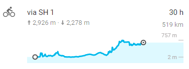
Firstly, if I thought 50Km would be be an easy, short day, I was quickly troubled by the elevation profile on Google.


Cycling profile from Queenstown to Glenorchy.

As you can see, there were no hugely long climbs, but the climbs came regularly and although short, were incredibly steep.  Not too bad on the way there, on reasonably fresh legs, but hellish on the way back when heavily fatigued.

There was a reward, though, stunning views beside the lake of the towering mountains in the distance.  I was starting to realise that the harder the cycle, generally the better the views.  It was a good source of motivation to keep going through the pain.

Once in Glenorchy, I had my sights set on at least one hike and that was up Mount Alfred, which I'd done a bit of research on and was supposed to give outstanding panoramic views of the mountains and valleys, and sat directly in the middle of a huge delta-like river mouth.  Again, however, there was a problem; everyone I asked about the hike said that the farmer who owned the land had shut the summit track to hikers a couple of months ago.  I could hike to the tree line, but no further.

The top of Mount Alfred.  Perhaps you could forgive me for bending the rules.

Well, I figured that it'd be unlikely the farmer would be guarding the track night and day, so I went up anyway.  The worst that could happen was that I was turned back.  As it turned out, the only problem I had was a steep, slightly icy in places, scramble to the top on not very much of a track.  Not much of a problem, if care was taken.  Bending the rules proved to give rich rewards once more, as a beautiful day yielded more spectacular views.

An older couple I met up there can just be seen bottom left of picture.

Funnily enough, the only people I met up there were an older couple, one of whom was a former park ranger on the Routeburn Track (one of the great hikes and a hike I was to start later on that day).  He said that he didn't really listen to what the Department of Conservation advised most of the time.  Their advice was mainly for the average Joe with no mountain or hiking experience.

It was a 360° view from the top.  The view from the other side wasn't bad either.

The hike up Mount Alfred wasn't an easy one.  The mountain was about 1500m high and the track was steep and ill-formed near the summit.  I needed to make good time because I formulated a plan to stay in a hut on the Routeburn Track overnight.  This meant hustling it up and down the mountain and cycling a further 25 Km or so, partly on rough, unsealed road, and then hiking a further 12 Km.  In all, the day was mounting-up on me; 75Km cycling and about 25+Km of hiking, a bit headless, especially as it was all rather steep.

The reason I was doing all this was to squeeze everything in before a slightly bad weather forecast the following day.  This happened quite often throughout the trip, I found myself pushing huge days just to beat the rain, which occurred quite frequently. Strenuous at the time, but when the rain hit, I often had days off or did just a short trail run in the rain or something, so I did have time to recover after the really physically arduous days.

I intended to park my bike up at the beginning of the Routeburn Track and do half of it and then come back down the next day.  The reason I didn't do all of it was that it was one-way, and the other side would require a lift by car of over 200Km to get back, and leaving my bike for that long just wasn't going to happen.  Glenorchy is surprisingly close to Milford Sound on the map, but is there are no roads though the mountains. The road at the other end of the Routeburn takes a massive detour.


The Routeburn Track is roughly where the red line is on the map.  Perhaps you can see how it was rather difficult to get back to my bike had I done the whole walk.

I only intended on making it to the second hut on the map, but the weather the next day was so unexpectedly good, I tried to make it to the Harris Saddle the next morning, which would've given me excellent views of the other side of the valley.

I actually didn't make it to the saddle for safety reasons.  Because of the fact I'd cycled to Glenorchy and planned to do the Routeburn at the last minute, I couldn't hire an ice axe and crampons and they were needed to get through one particular section safely. As I looked up at this part of the hike, however, I was very tempted to just go for it, as it was such a lovely day and the potential views were tempting me into a risky decision. I think I wisely decided not to continue though, especially as I was on my own, and if I got into trouble, there was no one there to help me.


If you look at the picture above, you will see a small section of snow just above a shear cliff face on the left-hand side.  The track passed through this, as I could see footprints in it.  Without the snow the track would be level, but as it was here, the snow meant that I would have had to cross it on an angle, and that angle lead to straight off the edge of the cliff.  To compound matters, it had rained quite a lot overnight, likely making the top of the snow loose and slippery and prone to give way underfoot.  As tempting as it was to just risk it, it would've been very dangerous and quite foolish on my own.  It was especially galling because there actually wasn't much snow and ice anywhere else on the track, just this tiny patch, probably less than 100 metres long, and there was no way around it.

When I came back down, I ironically met a volunteer rescuer, who had been part of a couple of rescues on the Routeburn Track this year.  What he told me made me glad of my decision.  Apparently, a couple of hikers got into trouble a few months previously and one fell to his death in precisely the fashion I had envisaged, losing his footing on the snow and sliding off the edge of a cliff.  The surviving woman then spent a month in one of the huts on the track (See this article in the Guardian).  Despite being on a popular and well-marked track, Winter conditions had trapped her and no one else passed-through in that time.  She undoubtedly would've run out of provisions within a few days, so surviving all that time must have been quite a feat.


I stayed the night in the huts at the bottom of the picture.

Aside from the disappointment of not being able to go further, the half of the Routeburn that I did complete didn't disappoint, as usual.  New Zealand is one of the few places in the world I have been to that truly never disappoints, I think this is because it is difficult to convey quite how awe-inspiring the scenery is in pictures.  It is always such a special feeling to actually be there, and not even the best photographers can quite capture the sensation you get when you experience these places in the flesh.


Glenorchy was another place that featured in The Lord of the Rings, this time as the backdrop for Isengaard, the home of Saruman, the white wizard.  Parts of the forest were also used for Lothlorien, the forest home of the elves.  Passing me and stopping at some scenic lookouts both on the way there and on the way back were small tour mini-buses with guides explaining the background and where it cropped-up in the films. They also had stories to tell about some of the main characters.

After an exhausting day hiking and biking, I contemplated staying in Glenorchy the following day, as I still had about 20Km of hiking to be done and 75Km of cycling if I wanted to get back to Queenstown.  Despite being yet another long day, I decided to just go all the way to Queenstown after the morning hiking.  A desperately difficult bike back down that horrendously hilly road ensued.

As I climbed one of the longer steeper hills on the way back, I saw someone stop ahead of me and get out of their car.  He looked at me waving, and as I moved closer I suddenly realised it was Alex, so I stopped and spoke to him in a fairly exhausted state. He had driven up to Glenorchy for the day with a friend who was visiting him shortly after me, I think it gave him a good idea how hard cycling around New Zealand can be sometimes.


A finally made it back to Queenstown, utterly shattered and resigned myself to a short day of cycling the following day, after a bit of a lie-in.  To cap-off a few crazy days, though, it ultimately wasn't to be that way as I made my way to Te Anau and the Sounds.

Monday 21 November 2016

Wanaka and Queenstown


After Mount Cook, I decided to get a lift with Alex to his home in Wanaka, where I stayed for a few days.  I was much in need of a rest and the homely atmosphere at Alex's place, along with the company of his housemates, was a nice change of pace and a bit more of a sociable atmosphere than I'd been used to over the past couple of weeks. I was glad of it, and Alex was a most hospitable host.

Wanaka was definitely my favourite town in New Zealand.  There was a nice mix of excitement and relaxation.  There was enough of a nightlife to keep night owls happy, enough adrenalin activities for the wild ones, enough hikes for the hardy trampers, and a peaceful lake and a relaxed town atmosphere for those who just wanted to put their feet up and relax.  It felt a bit like going back in time, from an Englishman's perspective; a place where you needn't lock your doors and the heating of houses was still done by wooden stoves.  It was a stunningly beautiful place to live, I was extremely envious.

The famous Wanaka tree

After doing a trail run in slightly cloudy weather up Mount Iron the day previously, the next day brought one of the hikes on my bucket list in New Zealand, Roy's Peak.  The problem was that I had arrived in early October and the Roy's Peak track was technically closed for lambing from October 1st to November 10th.  However, the skyline track, which was a longer trail of approximately 28Km, was not closed and this had the Roy's Peak track incorporated into its later stages.  Such a loophole in the rules was good enough for me.


The track started off through farmland some 8Km outside of Wanaka, so Alex kindly drove me out to the start point before he started work  The trail was boggy and poorly marked in the beginning, but I managed to find my way.  There were a couple of shallow river crossings before the real climb began.

I would climb up to about 1600m and then up and down along a ridgeline that overlooked Wanaka and gave splendid views of the lakes and the Southern Alps.  The view at Roy's Peak in particular is one of the most spectacular in the whole of New Zealand.


I made it to the top in good time and inscribed my name on the telegraph pole at the summit , then sat and had some lunch with my feet up, enjoying the splendor of what was laid out before my eyes.  I stayed up there for about an hour, not wanting to leave.

At the top of Roy's Peak.

One of he benefits of doing the hike when I possibly shouldn't have was that I had the mountain completely to myself, I saw no one but sheep the whole day.  After descending, I still had about 7 Km to go to get to Wanaka and decided to take the scenic route along the pristine shores of Lake Wanaka to finish the day.  In total, I'd hiked about 35Km.  Anyone who's done some hiking themselves in the mountains can tell you that anything over 20Km and you tend to feel it, so I was pretty exhausted.

Although I'd heard I was a wonderful house guest (and I helped them win the local pub quiz for the first time), especially compared to their previous visitors (a story that cannot be told without an 18 certificate), I didn't want to overstay my welcome and I decided to head on to Queenstown.

Before leaving, I tried to get myself in the right frame of mind for the day.  I only had to cover about 75Km, but it was over the highest sealed road in New Zealand, the Crown Range road.  Wanaka was by no means down at sea level, so I wasn't starting from zero elevation, but it was still my biggest climb of the trip so far.

The view from the top of the Crown Range road, the highest sealed road in New Zealand.

Starting steadily, the road began to ascend at an increasingly difficult gradient until it took all of my strength to just keep the pedals moving in my lowest gears, and all my concentration not to fall off the bike under the strain, as well as the fact I was going so slowly, making it harder to cycle in a clean straight line.  With cars and trucks passing and shear cliff faces rising one side and descending the other, you might see how this can start getting pretty hairy.  Still, with a lot of effort, leading to the heaviest I think I have ever breathed during and after exercise, I made it to the top and was rewarded with jaw-dropping views and a fun descent.

This was to be the start of an insane few days of hiking and biking.  After settling down into a hostel in Queenstown, the next day I decided to hike up Ben Lomond, a reasonably high mountain (1700m) that is easily accessible from the town.  It was a decent hike of about 7-8 hours total up and down and afforded tremendous views of Queenstown, the surrounding mountains, including, "The Remarkables", and lake Wakatipu.

The first part of the hike wound it's way through the forest and a maze of hiking trails intermingled with mountain biking tracks.  Things got a little confusing and I was glad to get beyond the tree line and beyond the tracks, even though the mountain biking did look quite fun.  I thought about how difficult it would be to ride a mountain bike without any weight on it after cycling with roughly 25kg on my bike for the last 4 weeks.

The summit of Ben Lomond

At the top of Ben Lomond I was joined once more by a couple of Kea.  One happily strutting around trying to distract the few of us who made the climb to the top from our bags, while the other snuck around the back of us to attempt to steal our food. Cheeky little devils.

After I made my way back down, I met up with another old friend from the UK, but this time just for a quick drink and a catch-up in a local pub.  I believe he had been living in Queenstown for the last 10 years or so.

It seemed like everyone I met in Queenstown was from the UK, certainly finding a kiwi was a tough task.  I was slightly vexed by the annoying lack of supermarkets in town and the exorbitant prices of the smaller stores.  I'd learned from Alex that many establishments had local prices and tourist prices.  I was pretty astonished, I'd never encountered this before in other places.


Aestheically, Queenstown is an absolute wonder and a mecca for extreme sports enthusiasts, but the town didn't do it for me as a place to live.  However, it is also very well placed to explore some of the most spectacular places in all of New Zealand, with a huge amount of tours to the Sounds and Glenorchy going from there.  I wasn't partaking, I was going my own way and I was starting with Glenorchy, which is the subject of my next post.

Wednesday 16 November 2016

The Dash to Mount Cook


The north island was behind me and I managed to board the ferry from Wellington to Picton a couple of days earlier than I'd originally booked.  Just as well, because my buddy Alex, who I was arranging to meet up with, sprang the news on me that he was only available in the first few days of October.  That left me with only a few days to get down to him in Wanaka, which was a tall order.  However, we formulated a plan, whereby I'd meet him a couple of hundred kilometres north of Wanaka in Mount Cook and have a bit of a hike there, and then maybe he could give me a lift in his car to Wanaka with him.

A great plan, but it still left me only 5 days to make it from Picton to Mount Cook Village.  A tough task even on flat ground, let alone going through the mountain passes of New Zealand.

This part of the road along the East coast is currently impassable due to land slips from the recent earthquake.
It turned out that the weather on the crossing over and the northern part of the South Island was terrible on the first day.  It rained heavily all day, and this did not bode well for doing the required miles, not to mention the lack of enjoyment such a day would entail.  With time and weather against me, I decided to hop on the train from Picton to Kaikoura (Kaikoura was at the centre of the recent major earthquake in New Zealand).

There aren't a lot of trains in New Zealand, and the only passenger trains in the South Island are slow moving scenic train journeys.  The weather being so bad, however, there wasn't much to see.

Cycling profile from Kaikoura to Mount Cook Village

After spending the night in Kaikoura, I still had a little over 500Km to do in 4 days, a doddle in Australia, but New Zealand is a different kettle of fish.  Fortunately, much of this distance was across the Canterbury plains in the Christchurch region, the flattest part of New Zealand.  I made good time on the first two days; going from Kaikoura to Christchurch (185Km) on day one, and Christchurch to Geraldine (approx 140km) on day two.  This meant shorter days firstly to Tekapo and then onto Mount Cook, which were both much harder on the legs due to some big climbs.


The east coast was rugged and bleak, but still quite majestic with tall mountains rising sharply out of the ocean and the road winding (thankfully) round them rather than up and down them.  Sheep and cows on the roadside were substituted for seals, some remarkably close to the roads edge, sitting on the rocks.

After passing along the coast, the road turned inland for some hard climbing, but then settled after about 30Km into the Canterbury Plains.  It was then flat and largely featureless, especially in quite cloudy weather, until just after Geraldine.  This section was probably the only featureless part of the whole trip, still, at least my camera was glad of a rest.

I knew the 90Km or so from Geraldine to Tekapo would be a shorter day, but a more arduous one, as there was a reasonable climb to get there.  It was actually quite steady for most of the way, except for the last kilometre, which really tested my legs, heart, and lungs.

Cycling profile from Geraldine to Tekapo.

Because I'd arrived fairly early in the day - at around 2 o'clock - I decided to hike up to Mount John Obervatory, which was about a 300 metre climb from the lakes and then loop down the lakeside back towards my hostel.  The walk took nearly 3 hours, and that pretty much finished me off for the day.  This was first real glimpse of the snow-capped mountains of the South Island and the incredible scenery to come.

At the top of Mount John with Lake Tekapo in the background.

The next day, I had almost exactly 100Km to cycle to get to Mount Cook Village, which sits in the shadow of the highest mountain in New Zealand, for my rendez-vous with my old chum from back home.

It was a really stunning cycle that day, especially the last 50Km after the absurdly blue lake Pukaki.  I sat for a while watching the fog lift and had a cup of coffee near a salmon visitors centre beside the lake.  The parking area was full of Chinese tourists having a rest stop and a photo-op from their coach tours.

The blue waters of Lake Pukaki

I have always found it interesting how men and women react to me when they see me and the bike and what I am doing.  Women typically react in astonishment and concern by saying I am crazy and asking me to take care and be careful on the roads.  Men on the other hand, are usually full of admiration and often ask me about the bike; many often say that they were thinking of doing something similar themselves.

A Chinese man came towards the bike, looking it up and down in curiosity for some few minutes.  It was a bit bizarre he didn't say anything to me, as I was right next to it, in fact he didn't even make eye contact. Perhaps he just didn't speak any English, still, he looked fascinated with it all, and then proceeded to take several pictures of a handsome-looking duck instead of the gorgeous view of the lake as the fog started to lift.

With thanks to Alex for taking this awesome picture of me with Mount Cook in the background.

After a difficult, but scenic 50 more kilometres, I arrived suitably tired in Mount Cook village and decided to take a rest in the afternoon and just wait for Alex to arrive. Never one to be on time, he was typically late, but that was fairly understandable given that he is a good photographer and he obviously spent some time taking a fair amount of pictures on the drive up.

It was good to see a familiar face and the next day's hiking gave me the opportunity to catch-up and to get some much needed photography tips, as well as having a few stunning photos taken of me with the amazing scenery.

Alex in action.

The hike also served-up my first encounter with the friendly and inquisitive Kea, the world's only alpine parrot.  I was to encounter these little rascals on several hikes and bikes through the mountains as I travelled further south.

This little guy posed for the camera a number of times, especially for Alex.  They look wonderful in flight when the fiery red underside of their wings can be seen.

Sometimes you visit a place that is so vast that it is humbling just to be there.  The mountains and valleys in this region definitely had this effect on me, as I reflected on how amazing it was to meet up with an old buddy, in such a spectacular place, on pretty much exactly the other side of the planet from where we last saw each other back home in England.


Monday 14 November 2016

Into Mordor - The Tongariro Northern Circuit

Mt Ngauruhoe (Mount Doom) from Whakapapa village. 

So I arrived in Whakapapa village in the pouring rain and had two days of doing nothing in a very wet holiday park.

The holiday park was so wet that pools of water were starting to form in the tent sites. Even after setting-up a tarp over my tent, things were beginning to look decidedly dodgy, so I called in one of the staff to take a look to see if there were any better options, as a flooded tent in the middle of the night was not really my cup of tea.

After a bit of subtle persuasion, I managed to wangle a cabin for the same price that night. Result.

The next day, and the weather was just as bad, but the boss was about and she could not be so easily persuaded. I made a passing comment about how it seemed unfair to pay 20 something dollars for a flooded campsite and off she went.

Apparently I was stupid for planning to stay in a tent in such conditions and her husband had put in a lot of effort to make the sites drain better, and I had offended her with such a statement.

Well, never one to pass-up an opportunity for an argument - and suffering from cabin fever and a horrible mouth ulcer, which made me a little less controlled than normal - a full-blown argument ensued, with the really helpful and nice chap, who helped me the night before, stuck in the middle trying to calm us both down.

To summarise what I had to say, I basically told her that if her husband showed the same levels of professionalism as her, it was no wonder the sites didn't drain very well. I didn't use any profanity, but to be fair, I was pretty rude and so was she.

The next morning, I decided to apologise and she did so in return, so it was all good in the end.

Anyway, eventually, it was time to set-off for what promised to be a pretty awesome hike, in the part of New Zealand where they filmed the scenes for Mordor in The Lord of the Rings.

I spoke to a young lady in the national park office and she basically told me not to attempt the full hike without an ice axe and crampons. I told her I needed to hire an ice axe, and she said the hire shop wouldn't hire me one if I was doing the hike on my own. So basically I couldn't do it (according to her).

Obviously I ignored her and tried to hire an ice axe anyway. I just said I was hiking with a friend who had one. They didn't ask any questions.

So despite being told not to, I thought I'd give the hike a go and just turn back if things got a little dodgy. As this turned out, however, I was in luck with the conditions.

First of all, the weather was fantastic, which afforded amazing views of the iconic volcanoes on both days. And secondly, all the rain over the previous few days had thawed a lot of the ice and snow, making things less treacherous underfoot and pretty much taking away the avalanche risk, which was my main concern.

It really was a spectacular hike, which I completed in less than two days.

I stayed overnight in a hut at the base of the ascent to the volcanic plateau. New Zealand's backcountry huts are very well serviced, even in winter, and have the advantage of having plastic mattresses to sleep on. Very comfortable, and saves space in the bag, not having to pack your own sleeping mat.

Beautiful hut to stay the night in.

The idyllic volcano in view in my pictures is Mt Ngauruhoe (as with many place names in NZ, impossible to pronounce). This was the volcano Peter Jackson used as, "Mount Doom", in The Lord of the Rings trilogy. In summer, when it is bereft of snow, it is totally black. I suspect the landscape is an interesting colour in summer, however, that's when the crowds gather, so I was quite happy with the place to myself in the snow.

Gorgeous views up at the Tama lakes.
In fact, throughout the vast majority of the hike, I saw no one. I shared my hut with two under-prepared Frenchmen, who were quite lucky the weather had made things easier on them. Even so, I think they might have struggled in the snow and ice that was left on the plateau the following morning.

I left the hut very early in the morning, as I thought the clouds might build up later and obscure the view somewhat. Turns out this is exactly what happened. I had perfect weather at the top of the plateau, with not a soul in sight. Absolutely breathtaking.  Not only were the volcanoes magnificent, but I could see for miles around, even as far as Mount Taranaki on the West coast.

There were some tough sections in the approximately 50km hike (if you include the side trips). I was glad of having an ice axe climbing up to the top of the red crater (see picture below), as it was incredibly steep and very slippery. Although much of the snow and ice had disappeared, there was still some to contend with here.

Apparently a couple of inexperienced hikers fell into this crater a month previous and had to be rescued.

Only as I was on my way down did I see anyone, and ironically the first person I saw was the nice helpful chap from the campsite. He, like everyone else, was coming up from the nearest car park, about a 5 hour walk to the plateau.

This was the easiest path to the top, and as I descended, I began to see more and more people, some kitted-out terribly for a potentially dangerous hike. No wonder the park office were trying to dissuade me from hiking, I guess that is their default position to assume that everyone was as stupid as these people.

As I passed these people, I was getting funny looks, the reason being is that I had a big bag and all the correct gear. Perhaps they thought I was over-prepared, but I was also doing a much longer hike than they were.

Started to see people from this point on the plateau, and they would've been in serious trouble if the weather took a turn for the worse.

It being a fairly warm and sunny day, most people were hiking in shorts and t-shirt and weren't carrying much warm clothing. They would have been freezing at the top, especially as the cloud was rolling in, as I predicted. Not long after I left the plateau, I looked back and could not see the top of Ngauruhoe and cloud was covering much of the plateau.

The view of Mt Ruhapehu, the biggest and most active of the volcanoes in the park.

I heard many stories of people getting themselves in trouble up on the plateau, and it was fairly easy to see why. One should never take mountains lightly, especially in winter/early spring.

"Gollum's Pool"
This was the centre-piece of the first leg of my tour and it didn't disappoint. A truly iconic place that had an eerily familiar feel to it because of its scenes in Lord of the Rings. It certainly wasn't hard to see why it was chosen to be Mordor, a spectacular and unique landscape.