Friday 23 December 2016

Doubtful Sound


Back in Te Anau, and with a very sore bottom, I was waiting for a weather window again so I could kayak Doubtful Sound.

Doubtful Sound was actually given its name by Captain Cook, who doubted it would be navigable by sail.  This was because he thought the wind rarely blew from the East in New Zealand (it is usually a Westerly or North-Westerly) making it doubtful one could exit the Sound after entering the depths of it.

Doubtful Sound is actually much bigger than Milford Sound, but one could argue slightly less spectacular.  However, Doubtful Sound has a wilderness quality to it.  It really is out of reach for the average traveller.  It's a long journey to get there, with few accommodation options, if any, once you are there.  As a result, a trip there gives you a sense of wild New Zealand you perhaps might not get at Milford Sound.  This is precisely why I chose to kayak there and camp overnight in the forest.

Doubtful Sound in cloud looked spectacular.

The Sound in clear conditions was probably more photogenic, but when there in person, the cloud really added to the atmosphere.

Again, I was fortunate enough to do this trip early in the season, before getting overly-popular.  It was easy to book at late notice, which was handy because I could check the weather forecast and not go on blind faith that the weather would be OK.  The weather had been unpredictable in this part of New Zealand even a week in advance, a couple of days out was usually okay.

The team.

I was joined on the trip by two Taiwanese chaps, who were brothers, one living in Queenstown.  They were great fun and very personable.  As well as our guide - a young Kiwi - a German girl made up the rest of the party.  It was a small group, perfect.

They were good fun, the brothers Taiwan.

I was picked-up from Te Anau and it was a short drive to Manapouri, then a 45 minute ferry ride across Lake Manapouri, and then a bus ride across to the Sound that took an hour and a half on a very rough road, hardly surprising given its remoteness.

The first day was cloudy, but in a very mystical and beautiful way.  The bus stopped at the top of a mountain pass and a magnificent view of the Sound, part draped in cloud, was laid-out before us.  The same view the next day was absolutely clear, but the cloud on day one made it seem like an almost fairytale place.  In fact, much of New Zealand feels this way to me, journeying through has a fantasy-land aura about it.

I'm not much of an adrenalin-seeker, but I do like an adventure, so kayaking seemed to fit this bill.  I had cycled, hiked, and run my way around New Zealand, but hadn't travelled under my own steam on water.


On each day, we were to kayak for about 5 hours, and it was surprising how tiring this was, it definitely caught-up with me.  It was a peaceful experience in pristine wilderness, and the vast majority of the time it was only our group out there.  On occasion we were to be joined by curious dolphins and Fjordland penguins swimming in the water.  The dolphins would surface right alongside our kayaks, interested in the novelty of them.

On top of the penguins and the dolphins, even before we entered the water as we packed the canoes on shore, a baby seal waddled out of the water along the beach of stones and into the trees.  We were all concerned, as it was without its mother, but apparently this is quite normal behaviour for seal pups.  I was never aware that seals ever ventured into the forest, let alone baby seals doing it on their own.


Our home for the night, in the forest with the sandflies.

We camped in one of the few flat areas of forest available in the Sound, nestled within the trees, it was quite difficult to find and once we were there absolutely swarming with sandflies.  The main communal tent had seats and a net around it, but still a few made their way in.  It was not for those without a sense of adventure or a tolerance for discomfort, for sure, but made for a great experience.


Looking out from camp at the end of day one.

After a bit to eat, it was time to hit the hay inside our tents.  My watch had stopped working that day, so I had no idea when to get up.  I would normally rise with the sun, but I wanted to be up a little before sunrise.  With this in mind, I woke up at a time that I felt was right and had some breakfast while looking at the Sound and the stars in the darkness.  As it turned out, I reckon I still had a few hours until sunrise, goodness knows what time it actually was.

Our camp was some distance away from where we needed to get back to, and with a little more exploration, we paddled at a reasonable speed, first to a gorgeous sandbank for a food stop, and then back to the canoe shed.

Not a bad place for a cup of tea and some scroggin.

The group had been a chatty bunch for most of the trip, but now everyone was strangely silent because we were simply exhausted and bugged-out by sandflies.  It came as a relief to get on the bus and away from those little blighters.  Still, it was an exceptional trip, and yet again a tourist activity that never felt like I was a tourist at all. In this day and age, it would seem improbable that one could go to a place so beautiful and it be so quiet and unspoiled by visitors.  It was a real privilege to bear witness to such natural splendor once again.


Thursday 15 December 2016

Milford Sound


Kepler Track done and dusted in two days, I now had to face one of the most difficult ascents of the trip to get to Milford Sound.

In total, it was about 120Km from Te Anau to Milford Sound.  The road there was fairly flat up until the divide and the start of the other end of the Routeburn Track, and then that's where the real climb began.

Actually, I knew that the real test would come coming out of Milford Sound the next day, as the climb was less steady.  The profile for the road reveals what I am talking about, but it was still a harsh climb on the way in also, especially with 75Km hiking in my legs over the last two days.

Cycling profile from Te Anau to Milford Sound.

In preparation for the tough couple of days of cycling, I left some of my camping equipment in the hostel in Te Anau, knowing that I'd have to go back there anyway.  I think this made a massive difference.  I probably shed only about 5-7kg, but it was amazing how much it helped.  I felt much fresher than expected.


As the climb started in earnest, any tiredness I was experiencing started to get pushed to the back of my mind as the exhilaration of the road began to take over.  The road into Milford Sound is supposed to be one of the best drives in the world by car, so you can imagine how majestic it seems on a bike, and how small you feel amidst the towering mountains all around you.

I passed several tour buses that were stopping in specific places for photo opportunities, receiving stares of disbelief aplenty.  I stopped a few times myself to take in the surroundings and take some photos.  It seemed as if every time I stopped, I was joined by this American couple from California.  The better-half of the couple was obviously quite keen on taking lots of photos, so I usually left before she finished.  With the head start, by the time the next point of interest came around, they had caught up, and the process repeated itself a couple of times after that.  They were both very nice, the man fascinated with my journey, as most men I met usually were.  His wife was typically concerned with my safety.

The other side of the tunnel and my jaw was on the floor.

Right at the top of the climb in and out of Milford Sound, there is a tunnel, about 1.2Km long, through the mountain.  As I waited for a green light to go through, I was joined by some friendly Kea again, looking very curious about my bike.  I expected the tunnel to be lit, and although it was a bit, it really hardly helped at all.  The tunnel was also much more narrow than I had envisioned, and even with my lights on it made it feel claustrophobic and dangerous with cars passing close to me and a bumpy surface beneath.  Fortunately, the Milford Road service people saw me enter the tunnel, stopped the traffic briefly and then offered to drive behind me with their lights on and chaperone me through.  Their intervention was most welcome.  They also said to wait for them on the way back up the following day and they could drive me and my bike through, as it would take much longer to pass through the tunnel going up hill.

Lots of Kea, and they were really intrigued by my bike.

As I exited the tunnel, the real splendor of the Milford Road showed itself.  The place was an absolute wonderland.  As it had rained recently, there were still temporary waterfalls cascading down sheer mountain cliffs, and the mountain peaks capped in snow rose so steeply from the ground, it almost hurt my neck to look up to them.  


The Kea joined me again, this time in a gang of about seven birds.  To make the experience even more memorable, the Kea - obviously intrigued by my bike - flew with me as I rode down the mountain, squawking excitedly as they soared alongside me.

I still had about 15Km to go to get to the Sound, but now it was all downhill in truly the most amazing scenery it is possible to imagine.  I sped down with a big smile on my face, checked into the Milford Lodge (the only accommodation in Milford Sound), and decided to sit at the mouth of the Sound, taking it all in.  All the cruises for the day had disembarked, so I had to wait for the morning anyway.


The tide was out, so I sat on a washed-up log for about an hour or so as the sun went down.  As I sat there on my own, I was delighted to see a dolphin porpoising out of the water really close to shore.  With perfect weather and the perfect backdrop as well, it really was quite a special moment.


The next day, I went on a cruise around the Sound.  Again, perhaps because it still wasn't peak season, even this managed not to feel very touristy.  I like what New Zealand has done with Milford Sound; despite the temptation to have lots of hotels and shops, they seem to have resisted it and the place feels more tranquil because of it, even if there are a lot of boats and light aircraft around.  In fact, the boats and planes give an impressive sense of scale to the place when you look out across the water.


Once I finished the cruise, I had some work to do.  It was unlikely I would make it all the way back to Te Anau, as I left the harbour at midday and I also wanted to hike up to lake Marian.  This trail began 1Km off the Milford road, about 30Km from Milford Sound, and was not a small hike.  I planned to stop and camp at one of the many DOC campsites further down the Milford road.

People kayaking near Lady Bowen Falls

The climb out of Milford Sound was something I was both relishing and dreading at the same time.  About 900 metres over 15Km is quite a stiff ask.  I found myself in good rhythm, though, and despite it being tough, I was confident that the climb wasn't going to defeat me.

I stopped about a kilometre short of the tunnel to take in the view.  The combination of exhaustion and a stiff cleat stuck in the pedal meant that, as I stopped, I toppled over to one side and fell off.  I was barely moving at the time, but my right hip took a painful blow on the tarmac.  It was the only time I fell off the bike on my whole trip.  As I picked myself up, who was there to help me?  Yep, it was that couple from California again.  I was to bump into them again at various times on the way down until I got to the Lake Marian hike, following the same pattern as when we kept meeting each other on the way into Milford Sound.

After taking some pictures, I jumped back on the bike and was offered a lift by a bit of a surfer-looking dude and his girlfriend in a bit of an old-looking car.  They said I could hold onto the window while they drag me along.  That seemed a smidge dangerous, and besides, my pride was forcing me to get to the top under my own volition, so I declined.

After about 10 minutes or so, I approached the entrance to the tunnel.  I was hoping the Milford road workers would be there to give me a lift through the tunnel, as they said they would.  I could see one of their trucks, which was a big relief.  They were there already seeing to a motorist whose car was overheating due to the climb.  It was the surfer dude.  As it turned out, my engine coped with the ascent a little better than the car's engine.  After they were helped, I threw my bike onto the truck and they gave me a lift through the tunnel.  Much appreciated, as it wasn't especially safe going through uphill on my bike, and I would have significantly held-up traffic.

About 10Km or so after the tunnel, I reached the start of the Lake Marian track.  The hike was quite steep and about 4 hours return for me.  Lake Marian was splendid reward for the effort, a high altitude lake with surrounding mountains.  I lingered there for a while before returning back to my bike.  I was a little anxious that the Kea hadn't messed-around with it.  There were plenty around in the car park as I left pulling at the rubber seals on the windscreens of cars with their sharp beaks.

Lake Marian

Bike in tact, I had about 4 hours until sunset.  As always, I pushed a little further than I intended until my choice of places to pitch a tent were rather few and far between.  I only had 25Km to go to get to Te Anau and a nice relaxing hostel, but it was well and truly dark, and I was well and truly tired.

I stopped in a camping area with very little grass, lots of rocks and stones, and no shelter in high winds.  I somehow pitched the tent, but didn't bother changing.  I just accepted it would be one of those miserable camping nights, and it was.  Very uncomfortable, hardly any sleep and a big mistake not to change, as the saddle sores that were developing were made much worse by sleeping in dirty clothes (do not make this mistake, always change clothes at the end of the day).  A very sore backside was the result and a painful 25Km back into Te Anau.

It was a relief to get back to Te Anau, and again, I had a couple of days of bad weather to wait out there before I could go to Doubtful sound.  This was just as well, because my bottom was so sore, I don't think I could've have ridden the bike for a couple of days anyway.  I recuperated, ate lots of food and was ready for a new experience and a new method of travel, kayaking in the wilderness of Doubtful Sound.


Tuesday 6 December 2016

The Kepler Track


One of New Zealand's great walks, the Kepler Track had been one of the first things on my to do list when I first planned to go to New Zealand, as it was more accessible and doable out of season when compared to the possibly more famous Milford Track.  As always, it didn't disappoint.

It was a tricky business squeezing-in 3 main trips in the Fjordland into weather-windows of good weather in the wettest part of New Zealand.  I managed things pretty well.  The first challenge was to figure-out how I could first do the Kepler Track and then have two good-weather days in order to get to Milford Sound and back.  I decided to risk the Kepler Track with a slightly dodgy weather forecast and go to Milford Sound on the two best days forecast for the week. This meant, however, doing the whole track in 2 days.


The Kepler Track is 60Km long, but I also had about a 5Km hike to get to the starting point.  So with the extra 5Km on the way back also, I needed to hike a total of approximately 70Km in 2 days.  This was not easy, especially when it is on mountainous terrain with lots of steep ascents.

I started as early as I possibly could, and the forecast for the first day was mixed, supposedly sunny spells, with the odd spot of rain and possibly snow on higher ground. The day before, I was safely in my hostel because of torrential rain, and this rain fell as snow in the mountains.  I was a little worried that this might have made the hike a little dangerous.

The track went right along the ridge, very exposed in bad weather, but awesome for views.

Luckily, there was no snow on the mountain passes before the downpour, so the fresh snow simply made the mountains and ridgelines more spectacular-looking.  The weather also lived-up to its forecast, with enough sunny spells and breaks in the clouds for the scenery to open-up all around me.  On the long traverse across the ridge, it was simply amazing.


I was making good time, but still had plenty of time to savour my surroundings and even do a little side-trip to a secluded waterfall.  Again, I saw few others attempting the hike, but about 6 or 7 hikers and a team of park rangers converged at the end of the day to spend a night in the same hut I was staying in.  The rangers were preparing the huts for the start of the Great Walks season, which was beginning after another couple of weeks.  Teams of them basically hike out to the huts and service them, reconnecting the gas supply, opening-up flush toilets, making sure they were all clean and tidy, that sort of thing.  Not a bad job, I reckon.

You can just about see an emergency hut camouflaged in the foreground. 

Every other hiker I met was doing the track over 4 days, which meant they had started in the god-awful weather the day previously.  However, I knew that day 2 on this hike for me wasn't going to be too pleasant.  The forecast was for rain all day again, which I knew already, but I had planned the hike so I would be traversing the ridge in the best weather, and that worked out very well.  All I had to do was put up with getting very wet in the trees on the way back down.

In heavy snow, I reckon the trail would have been a little hazardous.

I do quite enjoy forests in the rain, but 35Km in the rain was always going to be a little miserable.  Towards the end of the hike, being cold, wet, and exhausted, saying that the last few kilometres dragged a little would be quite the understatement.  Still, a degree of misery is part of the appeal of long hikes, runs, and bikes, and this year in particular, I have got quite used to this feeling.


Another stunning hike done, I now had a weather window of two days for my trip to Milford Sound.  I was hoping that using different muscles on the bike would mean that the exertion of the hike wouldn't affect me too much, as I had over 120Km to do to get there with some of the most severe climbs of the trip as well.  By this time, though, I could feel myself getting stronger, not a surprise given what I was putting my body through.  Turns out, there was plenty just off the road to keep me distracted from the physical effort.

Thursday 1 December 2016

Queenstown to Te Anau


When I arrived in Queenstown after my escapades in Glenorchy, my body was shot to pieces.  I arrived in the evening after 6 o'clock and contemplated just doing nothing the next day, but realised I had no food and I was a significant distance away from an affordable supermarket, due to Queenstown's tourist rates, so I had to leave.  Still, I set myself a modest target of only 50Km to a small town called Kingston, where there was a campsite I could pitch my tent.

I set off later than normal and only had about 10Km to go to hit a supermarket so I could get some provisions and a big lunch.  I felt slightly more energised after woofing-down some sushi, a pizza, and some chocolate and decided to check the weather forecast while I waited for my stomach to settle.

I had a problem, I was facing a stiff headwind on that day passing south along the shores of Lake Wakatipu, but more worryingly gale force headwinds the day after, and more worryingly still, gale force winds and torrential rain the day after that.  With no hostels between me and Te Anau (about 170Km away), I was torn between two options; have a big day and have about 60Km into the wind the next day, or wait out the bad weather in a campsite, in a small town with little to do, losing a couple of days in the process.  There was no contest really, I had to push through, despite my already tired body.

Into the wind, but at least the road out of Queenstown to Kingston was pretty.

Instead of a gentle 50Km, I pushed 120Km into the wind to get to a campsite in Mossburn.  Because of the winds and the fact I started later than normal, I got there as the sun was setting, one of the latest days cycling of the trip.  I do rather enjoy cycling at sunrise and sunset, however, particularly in areas of few people, it often has a beauty and peace you don't find at other parts of the day.

I met a fellow cycle tourer in the campsite.  He was only doing a circuit around the bottom of the South Island, but had his sights set on much greater things in the future. He was Argentinian and had cycled quite a lot in his own country, but was planning an around the world trip.  He was an interesting guy and we had quite a long chat in the camp kitchen while we were preparing and eating dinner.  This chat ended rather abruptly as 5 Chinese tourists came in and began shouting at each other continuously for about 30 minutes about who knows what.  They then proceeded to shout at each other once I settled-down to sleep, as well as moving their campervans to several different places in order to find the perfect place to park.  The concept of lowering your voice in consideration of others didn't seem to have taken hold in their collective mind.

I slept OK, despite the heated debates over parking, and woke to a magnificent sunrise and a very unique-looking sky.  The reason it was so special, however, was that the wind was blowing.  It was gusting from the west, and guess what direction I was travelling?

The cloud formations in the sky were strange, but beautiful all day due to the high winds.

As any cyclist will tell you, headwinds are our greatest nemesis, I would take steep hills any day.  Headwinds are dispiriting and exhausting for a number of reasons.  Not only is it simply physically harder, but it it crushes you mentally.  Flat, and even downhill sections become drudgery and hard-labour; there is no respite, no crest of a hill to aim for and then relax going down the opposite side.  Getting out of your seat to pump the pedals becomes counter-productive as you just create more wind-resistance.  This in turn makes your butt sore as you stay in the seat for longer.  The wind also can make you cold, and tends to cause your lips to get dry and sore.  Headwinds really cause the perfect storm of suffering on a bike, and when they're gusting, pedaling safely on the road without falling off or veering into traffic becomes another issue.

The 60Km from Mossburn to Te Anau was without doubt the hardest section of the trip. 60Km would normally take me about 3 hours, but instead took nearly seven.  It's not as if I rested much in that time either, as there were no towns or villages to stop at.  On one stretch in particular, where the mountains gave way to a vast plain, I could hardly pedal and the the blustery nature the wind started to make it dangerous, screwing with my balance on the bike.  Completely demoralised, at one stage I wondered whether I'd make it to Te Anau at all because I thought I might have to get off the bike and walk most of the 60Km.  Fortunately, however, as I hit more hills and mountains, I became slightly more sheltered from the worst of the wind.

It was a genuinely hellish day that I was glad to see the back of.  I arrived at the hostel in Te Anau safe in the knowledge I wouldn't be doing anything the next day because of the dismal weather forecast.  Sure enough, the next day it rained all day, so it was worth the effort.  I spent most of this day with my feet up eating chocolate, not feeling in the least bit guilty for doing absolutely nothing and piling in the calories.

I was again to run into Alex, as he was passing through with my thermos flask that I left at his place.  He was on his way to Milford Sound when news came through that the road was closed because of avalanche risk.  It was possibly opening later on in the day, so he came to the hostel I was staying at to put his feet up for a while and get more information.  Luckily for him, the road opened-up later on in the day, after a few planned explosions to set off controlled avalanches so the road was safe.

Te Anau was a pleasant little town, and all in all, I spent more time there than anywhere else on my New Zealand adventure.  It provided a good base for a few things I wanted to get done.  I had 2 main things in mind when I arrived, and that was the Kepler Track (a 60Km Great Walk), and a trip to Milford Sound and a boat cruise or kayak.  I had originally set my mind on kayaking Milford Sound, but then changed my mind as I learned a bit about Doubtful Sound.

Doubtful Sound is perhaps the less spectacular of the two major Sounds in the Fjordland, but it is much bigger and more remote, and therefore sees far less tourists because of it.  I thought this might be a better place for a kayaking trip.

Slightly scuppering my plans all along, though, was the weather.  I needed good weather for two days to make it to Milford Sound and back, and at least reasonably good weather for both Doubtful Sound and the Kepler Track.  I just about nailed it, waiting some days for rain to clear, first up was the Kepler Track, which is the subject of the next blog.

Friday 25 November 2016

Glenorchy


I said in the last post that the journey to Queenstown was the beginning of an insane few days.  Lumped in the middle of this was my little side trip to Glenorchy, a beautiful area of wilderness about 50Km from Queenstown along the shores of Lake Wakatipu.

Firstly, if I thought 50Km would be be an easy, short day, I was quickly troubled by the elevation profile on Google.


Cycling profile from Queenstown to Glenorchy.

As you can see, there were no hugely long climbs, but the climbs came regularly and although short, were incredibly steep.  Not too bad on the way there, on reasonably fresh legs, but hellish on the way back when heavily fatigued.

There was a reward, though, stunning views beside the lake of the towering mountains in the distance.  I was starting to realise that the harder the cycle, generally the better the views.  It was a good source of motivation to keep going through the pain.

Once in Glenorchy, I had my sights set on at least one hike and that was up Mount Alfred, which I'd done a bit of research on and was supposed to give outstanding panoramic views of the mountains and valleys, and sat directly in the middle of a huge delta-like river mouth.  Again, however, there was a problem; everyone I asked about the hike said that the farmer who owned the land had shut the summit track to hikers a couple of months ago.  I could hike to the tree line, but no further.

The top of Mount Alfred.  Perhaps you could forgive me for bending the rules.

Well, I figured that it'd be unlikely the farmer would be guarding the track night and day, so I went up anyway.  The worst that could happen was that I was turned back.  As it turned out, the only problem I had was a steep, slightly icy in places, scramble to the top on not very much of a track.  Not much of a problem, if care was taken.  Bending the rules proved to give rich rewards once more, as a beautiful day yielded more spectacular views.

An older couple I met up there can just be seen bottom left of picture.

Funnily enough, the only people I met up there were an older couple, one of whom was a former park ranger on the Routeburn Track (one of the great hikes and a hike I was to start later on that day).  He said that he didn't really listen to what the Department of Conservation advised most of the time.  Their advice was mainly for the average Joe with no mountain or hiking experience.

It was a 360° view from the top.  The view from the other side wasn't bad either.

The hike up Mount Alfred wasn't an easy one.  The mountain was about 1500m high and the track was steep and ill-formed near the summit.  I needed to make good time because I formulated a plan to stay in a hut on the Routeburn Track overnight.  This meant hustling it up and down the mountain and cycling a further 25 Km or so, partly on rough, unsealed road, and then hiking a further 12 Km.  In all, the day was mounting-up on me; 75Km cycling and about 25+Km of hiking, a bit headless, especially as it was all rather steep.

The reason I was doing all this was to squeeze everything in before a slightly bad weather forecast the following day.  This happened quite often throughout the trip, I found myself pushing huge days just to beat the rain, which occurred quite frequently. Strenuous at the time, but when the rain hit, I often had days off or did just a short trail run in the rain or something, so I did have time to recover after the really physically arduous days.

I intended to park my bike up at the beginning of the Routeburn Track and do half of it and then come back down the next day.  The reason I didn't do all of it was that it was one-way, and the other side would require a lift by car of over 200Km to get back, and leaving my bike for that long just wasn't going to happen.  Glenorchy is surprisingly close to Milford Sound on the map, but is there are no roads though the mountains. The road at the other end of the Routeburn takes a massive detour.


The Routeburn Track is roughly where the red line is on the map.  Perhaps you can see how it was rather difficult to get back to my bike had I done the whole walk.

I only intended on making it to the second hut on the map, but the weather the next day was so unexpectedly good, I tried to make it to the Harris Saddle the next morning, which would've given me excellent views of the other side of the valley.

I actually didn't make it to the saddle for safety reasons.  Because of the fact I'd cycled to Glenorchy and planned to do the Routeburn at the last minute, I couldn't hire an ice axe and crampons and they were needed to get through one particular section safely. As I looked up at this part of the hike, however, I was very tempted to just go for it, as it was such a lovely day and the potential views were tempting me into a risky decision. I think I wisely decided not to continue though, especially as I was on my own, and if I got into trouble, there was no one there to help me.


If you look at the picture above, you will see a small section of snow just above a shear cliff face on the left-hand side.  The track passed through this, as I could see footprints in it.  Without the snow the track would be level, but as it was here, the snow meant that I would have had to cross it on an angle, and that angle lead to straight off the edge of the cliff.  To compound matters, it had rained quite a lot overnight, likely making the top of the snow loose and slippery and prone to give way underfoot.  As tempting as it was to just risk it, it would've been very dangerous and quite foolish on my own.  It was especially galling because there actually wasn't much snow and ice anywhere else on the track, just this tiny patch, probably less than 100 metres long, and there was no way around it.

When I came back down, I ironically met a volunteer rescuer, who had been part of a couple of rescues on the Routeburn Track this year.  What he told me made me glad of my decision.  Apparently, a couple of hikers got into trouble a few months previously and one fell to his death in precisely the fashion I had envisaged, losing his footing on the snow and sliding off the edge of a cliff.  The surviving woman then spent a month in one of the huts on the track (See this article in the Guardian).  Despite being on a popular and well-marked track, Winter conditions had trapped her and no one else passed-through in that time.  She undoubtedly would've run out of provisions within a few days, so surviving all that time must have been quite a feat.


I stayed the night in the huts at the bottom of the picture.

Aside from the disappointment of not being able to go further, the half of the Routeburn that I did complete didn't disappoint, as usual.  New Zealand is one of the few places in the world I have been to that truly never disappoints, I think this is because it is difficult to convey quite how awe-inspiring the scenery is in pictures.  It is always such a special feeling to actually be there, and not even the best photographers can quite capture the sensation you get when you experience these places in the flesh.


Glenorchy was another place that featured in The Lord of the Rings, this time as the backdrop for Isengaard, the home of Saruman, the white wizard.  Parts of the forest were also used for Lothlorien, the forest home of the elves.  Passing me and stopping at some scenic lookouts both on the way there and on the way back were small tour mini-buses with guides explaining the background and where it cropped-up in the films. They also had stories to tell about some of the main characters.

After an exhausting day hiking and biking, I contemplated staying in Glenorchy the following day, as I still had about 20Km of hiking to be done and 75Km of cycling if I wanted to get back to Queenstown.  Despite being yet another long day, I decided to just go all the way to Queenstown after the morning hiking.  A desperately difficult bike back down that horrendously hilly road ensued.

As I climbed one of the longer steeper hills on the way back, I saw someone stop ahead of me and get out of their car.  He looked at me waving, and as I moved closer I suddenly realised it was Alex, so I stopped and spoke to him in a fairly exhausted state. He had driven up to Glenorchy for the day with a friend who was visiting him shortly after me, I think it gave him a good idea how hard cycling around New Zealand can be sometimes.


A finally made it back to Queenstown, utterly shattered and resigned myself to a short day of cycling the following day, after a bit of a lie-in.  To cap-off a few crazy days, though, it ultimately wasn't to be that way as I made my way to Te Anau and the Sounds.

Monday 21 November 2016

Wanaka and Queenstown


After Mount Cook, I decided to get a lift with Alex to his home in Wanaka, where I stayed for a few days.  I was much in need of a rest and the homely atmosphere at Alex's place, along with the company of his housemates, was a nice change of pace and a bit more of a sociable atmosphere than I'd been used to over the past couple of weeks. I was glad of it, and Alex was a most hospitable host.

Wanaka was definitely my favourite town in New Zealand.  There was a nice mix of excitement and relaxation.  There was enough of a nightlife to keep night owls happy, enough adrenalin activities for the wild ones, enough hikes for the hardy trampers, and a peaceful lake and a relaxed town atmosphere for those who just wanted to put their feet up and relax.  It felt a bit like going back in time, from an Englishman's perspective; a place where you needn't lock your doors and the heating of houses was still done by wooden stoves.  It was a stunningly beautiful place to live, I was extremely envious.

The famous Wanaka tree

After doing a trail run in slightly cloudy weather up Mount Iron the day previously, the next day brought one of the hikes on my bucket list in New Zealand, Roy's Peak.  The problem was that I had arrived in early October and the Roy's Peak track was technically closed for lambing from October 1st to November 10th.  However, the skyline track, which was a longer trail of approximately 28Km, was not closed and this had the Roy's Peak track incorporated into its later stages.  Such a loophole in the rules was good enough for me.


The track started off through farmland some 8Km outside of Wanaka, so Alex kindly drove me out to the start point before he started work  The trail was boggy and poorly marked in the beginning, but I managed to find my way.  There were a couple of shallow river crossings before the real climb began.

I would climb up to about 1600m and then up and down along a ridgeline that overlooked Wanaka and gave splendid views of the lakes and the Southern Alps.  The view at Roy's Peak in particular is one of the most spectacular in the whole of New Zealand.


I made it to the top in good time and inscribed my name on the telegraph pole at the summit , then sat and had some lunch with my feet up, enjoying the splendor of what was laid out before my eyes.  I stayed up there for about an hour, not wanting to leave.

At the top of Roy's Peak.

One of he benefits of doing the hike when I possibly shouldn't have was that I had the mountain completely to myself, I saw no one but sheep the whole day.  After descending, I still had about 7 Km to go to get to Wanaka and decided to take the scenic route along the pristine shores of Lake Wanaka to finish the day.  In total, I'd hiked about 35Km.  Anyone who's done some hiking themselves in the mountains can tell you that anything over 20Km and you tend to feel it, so I was pretty exhausted.

Although I'd heard I was a wonderful house guest (and I helped them win the local pub quiz for the first time), especially compared to their previous visitors (a story that cannot be told without an 18 certificate), I didn't want to overstay my welcome and I decided to head on to Queenstown.

Before leaving, I tried to get myself in the right frame of mind for the day.  I only had to cover about 75Km, but it was over the highest sealed road in New Zealand, the Crown Range road.  Wanaka was by no means down at sea level, so I wasn't starting from zero elevation, but it was still my biggest climb of the trip so far.

The view from the top of the Crown Range road, the highest sealed road in New Zealand.

Starting steadily, the road began to ascend at an increasingly difficult gradient until it took all of my strength to just keep the pedals moving in my lowest gears, and all my concentration not to fall off the bike under the strain, as well as the fact I was going so slowly, making it harder to cycle in a clean straight line.  With cars and trucks passing and shear cliff faces rising one side and descending the other, you might see how this can start getting pretty hairy.  Still, with a lot of effort, leading to the heaviest I think I have ever breathed during and after exercise, I made it to the top and was rewarded with jaw-dropping views and a fun descent.

This was to be the start of an insane few days of hiking and biking.  After settling down into a hostel in Queenstown, the next day I decided to hike up Ben Lomond, a reasonably high mountain (1700m) that is easily accessible from the town.  It was a decent hike of about 7-8 hours total up and down and afforded tremendous views of Queenstown, the surrounding mountains, including, "The Remarkables", and lake Wakatipu.

The first part of the hike wound it's way through the forest and a maze of hiking trails intermingled with mountain biking tracks.  Things got a little confusing and I was glad to get beyond the tree line and beyond the tracks, even though the mountain biking did look quite fun.  I thought about how difficult it would be to ride a mountain bike without any weight on it after cycling with roughly 25kg on my bike for the last 4 weeks.

The summit of Ben Lomond

At the top of Ben Lomond I was joined once more by a couple of Kea.  One happily strutting around trying to distract the few of us who made the climb to the top from our bags, while the other snuck around the back of us to attempt to steal our food. Cheeky little devils.

After I made my way back down, I met up with another old friend from the UK, but this time just for a quick drink and a catch-up in a local pub.  I believe he had been living in Queenstown for the last 10 years or so.

It seemed like everyone I met in Queenstown was from the UK, certainly finding a kiwi was a tough task.  I was slightly vexed by the annoying lack of supermarkets in town and the exorbitant prices of the smaller stores.  I'd learned from Alex that many establishments had local prices and tourist prices.  I was pretty astonished, I'd never encountered this before in other places.


Aestheically, Queenstown is an absolute wonder and a mecca for extreme sports enthusiasts, but the town didn't do it for me as a place to live.  However, it is also very well placed to explore some of the most spectacular places in all of New Zealand, with a huge amount of tours to the Sounds and Glenorchy going from there.  I wasn't partaking, I was going my own way and I was starting with Glenorchy, which is the subject of my next post.

Wednesday 16 November 2016

The Dash to Mount Cook


The north island was behind me and I managed to board the ferry from Wellington to Picton a couple of days earlier than I'd originally booked.  Just as well, because my buddy Alex, who I was arranging to meet up with, sprang the news on me that he was only available in the first few days of October.  That left me with only a few days to get down to him in Wanaka, which was a tall order.  However, we formulated a plan, whereby I'd meet him a couple of hundred kilometres north of Wanaka in Mount Cook and have a bit of a hike there, and then maybe he could give me a lift in his car to Wanaka with him.

A great plan, but it still left me only 5 days to make it from Picton to Mount Cook Village.  A tough task even on flat ground, let alone going through the mountain passes of New Zealand.

This part of the road along the East coast is currently impassable due to land slips from the recent earthquake.
It turned out that the weather on the crossing over and the northern part of the South Island was terrible on the first day.  It rained heavily all day, and this did not bode well for doing the required miles, not to mention the lack of enjoyment such a day would entail.  With time and weather against me, I decided to hop on the train from Picton to Kaikoura (Kaikoura was at the centre of the recent major earthquake in New Zealand).

There aren't a lot of trains in New Zealand, and the only passenger trains in the South Island are slow moving scenic train journeys.  The weather being so bad, however, there wasn't much to see.

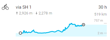
Cycling profile from Kaikoura to Mount Cook Village

After spending the night in Kaikoura, I still had a little over 500Km to do in 4 days, a doddle in Australia, but New Zealand is a different kettle of fish.  Fortunately, much of this distance was across the Canterbury plains in the Christchurch region, the flattest part of New Zealand.  I made good time on the first two days; going from Kaikoura to Christchurch (185Km) on day one, and Christchurch to Geraldine (approx 140km) on day two.  This meant shorter days firstly to Tekapo and then onto Mount Cook, which were both much harder on the legs due to some big climbs.


The east coast was rugged and bleak, but still quite majestic with tall mountains rising sharply out of the ocean and the road winding (thankfully) round them rather than up and down them.  Sheep and cows on the roadside were substituted for seals, some remarkably close to the roads edge, sitting on the rocks.

After passing along the coast, the road turned inland for some hard climbing, but then settled after about 30Km into the Canterbury Plains.  It was then flat and largely featureless, especially in quite cloudy weather, until just after Geraldine.  This section was probably the only featureless part of the whole trip, still, at least my camera was glad of a rest.

I knew the 90Km or so from Geraldine to Tekapo would be a shorter day, but a more arduous one, as there was a reasonable climb to get there.  It was actually quite steady for most of the way, except for the last kilometre, which really tested my legs, heart, and lungs.

Cycling profile from Geraldine to Tekapo.

Because I'd arrived fairly early in the day - at around 2 o'clock - I decided to hike up to Mount John Obervatory, which was about a 300 metre climb from the lakes and then loop down the lakeside back towards my hostel.  The walk took nearly 3 hours, and that pretty much finished me off for the day.  This was first real glimpse of the snow-capped mountains of the South Island and the incredible scenery to come.

At the top of Mount John with Lake Tekapo in the background.

The next day, I had almost exactly 100Km to cycle to get to Mount Cook Village, which sits in the shadow of the highest mountain in New Zealand, for my rendez-vous with my old chum from back home.

It was a really stunning cycle that day, especially the last 50Km after the absurdly blue lake Pukaki.  I sat for a while watching the fog lift and had a cup of coffee near a salmon visitors centre beside the lake.  The parking area was full of Chinese tourists having a rest stop and a photo-op from their coach tours.

The blue waters of Lake Pukaki

I have always found it interesting how men and women react to me when they see me and the bike and what I am doing.  Women typically react in astonishment and concern by saying I am crazy and asking me to take care and be careful on the roads.  Men on the other hand, are usually full of admiration and often ask me about the bike; many often say that they were thinking of doing something similar themselves.

A Chinese man came towards the bike, looking it up and down in curiosity for some few minutes.  It was a bit bizarre he didn't say anything to me, as I was right next to it, in fact he didn't even make eye contact. Perhaps he just didn't speak any English, still, he looked fascinated with it all, and then proceeded to take several pictures of a handsome-looking duck instead of the gorgeous view of the lake as the fog started to lift.

With thanks to Alex for taking this awesome picture of me with Mount Cook in the background.

After a difficult, but scenic 50 more kilometres, I arrived suitably tired in Mount Cook village and decided to take a rest in the afternoon and just wait for Alex to arrive. Never one to be on time, he was typically late, but that was fairly understandable given that he is a good photographer and he obviously spent some time taking a fair amount of pictures on the drive up.

It was good to see a familiar face and the next day's hiking gave me the opportunity to catch-up and to get some much needed photography tips, as well as having a few stunning photos taken of me with the amazing scenery.

Alex in action.

The hike also served-up my first encounter with the friendly and inquisitive Kea, the world's only alpine parrot.  I was to encounter these little rascals on several hikes and bikes through the mountains as I travelled further south.

This little guy posed for the camera a number of times, especially for Alex.  They look wonderful in flight when the fiery red underside of their wings can be seen.

Sometimes you visit a place that is so vast that it is humbling just to be there.  The mountains and valleys in this region definitely had this effect on me, as I reflected on how amazing it was to meet up with an old buddy, in such a spectacular place, on pretty much exactly the other side of the planet from where we last saw each other back home in England.