Monday, 14 November 2016

Into Mordor - The Tongariro Northern Circuit

Mt Ngauruhoe (Mount Doom) from Whakapapa village. 

So I arrived in Whakapapa village in the pouring rain and had two days of doing nothing in a very wet holiday park.

The holiday park was so wet that pools of water were starting to form in the tent sites. Even after setting-up a tarp over my tent, things were beginning to look decidedly dodgy, so I called in one of the staff to take a look to see if there were any better options, as a flooded tent in the middle of the night was not really my cup of tea.

After a bit of subtle persuasion, I managed to wangle a cabin for the same price that night. Result.

The next day, and the weather was just as bad, but the boss was about and she could not be so easily persuaded. I made a passing comment about how it seemed unfair to pay 20 something dollars for a flooded campsite and off she went.

Apparently I was stupid for planning to stay in a tent in such conditions and her husband had put in a lot of effort to make the sites drain better, and I had offended her with such a statement.

Well, never one to pass-up an opportunity for an argument - and suffering from cabin fever and a horrible mouth ulcer, which made me a little less controlled than normal - a full-blown argument ensued, with the really helpful and nice chap, who helped me the night before, stuck in the middle trying to calm us both down.

To summarise what I had to say, I basically told her that if her husband showed the same levels of professionalism as her, it was no wonder the sites didn't drain very well. I didn't use any profanity, but to be fair, I was pretty rude and so was she.

The next morning, I decided to apologise and she did so in return, so it was all good in the end.

Anyway, eventually, it was time to set-off for what promised to be a pretty awesome hike, in the part of New Zealand where they filmed the scenes for Mordor in The Lord of the Rings.

I spoke to a young lady in the national park office and she basically told me not to attempt the full hike without an ice axe and crampons. I told her I needed to hire an ice axe, and she said the hire shop wouldn't hire me one if I was doing the hike on my own. So basically I couldn't do it (according to her).

Obviously I ignored her and tried to hire an ice axe anyway. I just said I was hiking with a friend who had one. They didn't ask any questions.

So despite being told not to, I thought I'd give the hike a go and just turn back if things got a little dodgy. As this turned out, however, I was in luck with the conditions.

First of all, the weather was fantastic, which afforded amazing views of the iconic volcanoes on both days. And secondly, all the rain over the previous few days had thawed a lot of the ice and snow, making things less treacherous underfoot and pretty much taking away the avalanche risk, which was my main concern.

It really was a spectacular hike, which I completed in less than two days.

I stayed overnight in a hut at the base of the ascent to the volcanic plateau. New Zealand's backcountry huts are very well serviced, even in winter, and have the advantage of having plastic mattresses to sleep on. Very comfortable, and saves space in the bag, not having to pack your own sleeping mat.

Beautiful hut to stay the night in.

The idyllic volcano in view in my pictures is Mt Ngauruhoe (as with many place names in NZ, impossible to pronounce). This was the volcano Peter Jackson used as, "Mount Doom", in The Lord of the Rings trilogy. In summer, when it is bereft of snow, it is totally black. I suspect the landscape is an interesting colour in summer, however, that's when the crowds gather, so I was quite happy with the place to myself in the snow.

Gorgeous views up at the Tama lakes.
In fact, throughout the vast majority of the hike, I saw no one. I shared my hut with two under-prepared Frenchmen, who were quite lucky the weather had made things easier on them. Even so, I think they might have struggled in the snow and ice that was left on the plateau the following morning.

I left the hut very early in the morning, as I thought the clouds might build up later and obscure the view somewhat. Turns out this is exactly what happened. I had perfect weather at the top of the plateau, with not a soul in sight. Absolutely breathtaking.  Not only were the volcanoes magnificent, but I could see for miles around, even as far as Mount Taranaki on the West coast.

There were some tough sections in the approximately 50km hike (if you include the side trips). I was glad of having an ice axe climbing up to the top of the red crater (see picture below), as it was incredibly steep and very slippery. Although much of the snow and ice had disappeared, there was still some to contend with here.

Apparently a couple of inexperienced hikers fell into this crater a month previous and had to be rescued.

Only as I was on my way down did I see anyone, and ironically the first person I saw was the nice helpful chap from the campsite. He, like everyone else, was coming up from the nearest car park, about a 5 hour walk to the plateau.

This was the easiest path to the top, and as I descended, I began to see more and more people, some kitted-out terribly for a potentially dangerous hike. No wonder the park office were trying to dissuade me from hiking, I guess that is their default position to assume that everyone was as stupid as these people.

As I passed these people, I was getting funny looks, the reason being is that I had a big bag and all the correct gear. Perhaps they thought I was over-prepared, but I was also doing a much longer hike than they were.

Started to see people from this point on the plateau, and they would've been in serious trouble if the weather took a turn for the worse.

It being a fairly warm and sunny day, most people were hiking in shorts and t-shirt and weren't carrying much warm clothing. They would have been freezing at the top, especially as the cloud was rolling in, as I predicted. Not long after I left the plateau, I looked back and could not see the top of Ngauruhoe and cloud was covering much of the plateau.

The view of Mt Ruhapehu, the biggest and most active of the volcanoes in the park.

I heard many stories of people getting themselves in trouble up on the plateau, and it was fairly easy to see why. One should never take mountains lightly, especially in winter/early spring.

"Gollum's Pool"
This was the centre-piece of the first leg of my tour and it didn't disappoint. A truly iconic place that had an eerily familiar feel to it because of its scenes in Lord of the Rings. It certainly wasn't hard to see why it was chosen to be Mordor, a spectacular and unique landscape.


Saturday, 29 October 2016

On the Road - Through the North Island


These blogs are considerably delayed, but hopefully I can start getting them out at a better rate. Anyway,  after the Coromandel, I made my way south and right down the middle of the North Island.  The centre piece of the first part of my trip was the Tongariro National Park (I will devote a separate post for this), but on the way, I passed through many places of interest.


My first major destination after the Coromandel was Rotorua.

I stopped for a pie near Tauranga - after cycling through more endlessly steep hills. I bumped into a nice young man at a petrol station who gave me the good news that Rotorua was pretty flat and that I didn't have too many hills to climb. He seemed genuine, and I'm sure he was, but he was dead wrong, and which psychologically didn't do me much good.

View over Rotorua lake

Yes, Rotorua, once you are there, is quite flat, but it took an awful lot of climbing to get there, passing through one gorge in particular that was fairly hair-raising going into and exhausting coming out of.

A tough 110Km leg to Rotorua.

Rotorua itself is a stinky but interesting place. So much volcanic activity sends out a fair amount of sulphurous gas into the air from various locations all over the city. I met a Korean chap who thought it good for health, although I don't see how that could be.

There was a very obvious Korean presence across the city. I met a number of Koreans and there were many korean shops and restaurants, and even souvenir shops with Korean writing and no Chinese. This made me think that Rotorua was well marketed in Korea, perhaps for the health benefits of breathing sulpurous gas? Who knows, but it wouldn't be out of character for Koreans to be obsessed with dubious claims of the supposed health benefits of something rather odd.

Steaming small lake in Rotorua

I moved on to Taupo, which was quite cloudy, unfortunately. On the way I hit several geothermal areas and was tempted to pay for one in particular, but had seen enough bubbling, steaming stuff in Rotorua, not to mention that the weather was not especially nice.

Huka falls was a worthwhile side trip. Although not particularly high, Huka falls is astoundingly powerful and the water incredibly blue.


On then to Turangi, again in bad weather, a theme that was to last a few days. In the pouring rain, and with a literal mountain to climb, I decided to cheat (I earned this in Australia, where no alternative methods of transport were used at all) and hop on a minibus up to Whakapapa village (the base for the Tongariro Northern Circuit, a NZ great walk), about a 50km very uphill journey in the pouring rain I was glad to miss out on.

More about this in the next post, but I was certainly glad of my lack of planning with all the rain about. On the bus with me were two German girls who had booked a guided Northern Crossing walk (the famous one day walk), and only had the time for that one day. The weather had to be good, but it was chucking it down with rain. If they went at all, they would've seen nothing and been pretty wet and miserable. I, on the other hand, had the flexibility to wait for a weather window.

While I was waiting for the weather to clear, I did manage to get on to a smaller hike to a waterfall, and as chance would have it, my timing was perfect to see a couple of people kayak down it.  The falls themselves featured in The Lord of the Rings as the background to Gollum eating a fish.


After I had finished my walk in Tongariro, I quickly whizzed down the mountain to National Park Village. I intended to do a hike there the next day but the weather wasn't great. What I didn't know was that the weather was going to get even worse, unexpectedly so as it wasn't forecast to (the weather in New Zealand appears somewhat tricky to forecast correctly).

After just 30km I was soaked and very cold, a deep cold that I couldn't shake the whole day and that left me feeling decidedly unwell.

After eating no food for 12 hours and being woken by air-raid sirens, which I thought were signaling a volcanic eruption (I was later to learn that they are actually to call volunteer firemen), I set off the next day to Whanganui via the scenic Whanganui river road.

Although more down than up, the road still climbed over 1000 metres during the day,  a massive task for a man with no fuel in the tank. The road itself was beautiful though, which provided enough distraction to get me through.

Once in Whanganui, I was relieved that I could eat normally again and that my bad stomach was only to last a day.

After that, it was a fairly uninteresting journey to Wellington. I stopped in a small town for lunch called "Bulls", which the people obviously enjoyed making puns out of.


Concentrated punnery in one big sign.

I finally reached Wellington, a few days ahead of schedule. Fortunately, I was able to jump on an earlier boat to the South Island. Instead of arriving on the 28th, I could now arrive 2 days earlier.

I still had the best part of a day and a half to explore Wellington, which was a very pleasant city. I went for a run, first along the bay, and then hooked up with the southern walkway, which took me over the hills and to the suburbs on the opposite coast.

It was a good 17km in all, a length of run I hadn't done in a while, so I was pretty tired. Just in case you are wondering, cycling a lot doesn't help you run at all, in fact just the reverse (my legs wondered what the hell they were doing).

Wellington has a network of nice trails up into the forested hills throughout the city and suburbs. From the high points I could see all around, including the international cricket ground and a very small airport, nestled in the neck between two parts of the city, with the sea at the start and finish of the runway.

I will see Wellington again on the way back to Auckland for my flight home, but it was time to say farewell to the north island for the moment. It was time for the much anticipated South, and it certainly hasn't disappointed so far.

The postcard picture of Wellington and it's famous old ratchety cable car.

Wednesday, 5 October 2016

The North Island Part 1 - the Coromandel and the Unexpected


Apologies for the lack of blogs so far on this trip, but because of some battery problems with my phone, it was out of action for a couple of weeks. This meant I was unable to get into my blogger account, as Google was suspicious of my location. I had similar trouble with my email also.

So, to the trip then and I have a few blogs to catch up on because a lot more happens on the average day than in Australia. New Zealand has definitely been an adventure so far. Things really couldn't be any more different from Australia, in a number of ways.

Obviously the climate and the ascending and descending nature of the roads was always going to be a contrast, but many more unforseen circumstances have cropped up on this trip. I've had to roll with a few punches so far and also just accept that the weather is simply going to win sometimes and not fight the elements too hard.

Mini disasters have definitely plagued me in New Zealand. In Australia, I don't think anything went wrong at all, everything just went perfectly to plan. New Zealand, a slightly different story. Nothing really major, but annoying little inconveniences:

- I forgot my cycling shoes and had to buy a new pair on arrival.

- I broke one of my cycle locks, when the key snapped in the lock on the first day. This meant I had to saw through the cable with my camp knife to avoid my bike being permanently locked to a fence (just as well I have a good quality knife). While sawing through the lock, I was simultaneously stung on the back of the neck by a wasp.

Hunua Falls, a little before the Coromandel and my first stop and where I had to saw off my cycle lock, with some suspicious eyes looking at me.

- Perhaps as an after-effect from the physical stress of the Darwin to Melbourne dash, I developed the biggest mouth ulcer on the inside of my mouth.

I could feel a dull ache deep inside my cheek when I was in Melbourne and after a day or so in New Zealand a big blister developed inside my mouth about the size of my little finger nail. This became extraordinarily painful after a few days and lasted for about a week.

The pain was so intense it was making my whole mouth hurt and giving me headaches, which really made me consider going to the doctor, just in case it was infected. Fortunately, it (very slowly) started improving, although it did make me pretty miserable for a while.

- Just as I was starting to be able to eat again, an unforecast heavy bout of rain in cold weather chilled me to the bone, which I couldn't shake all day, despite finishing early and sitting in front of a log fire with several layers on. This then made feel sick and I ate nothing from 10am until about 2pm the next day. After managing to hold down some Tom Yum soup in Whanganui, though, I was back to normal.

- As previously mentioned, after a couple of days, the battery on my phone decided to pack-in. I had to order one online and then have it sent to Wellington for pick up. This meant I couldn't contact anyone and also that Yahoo and Google were suspicious of my location and locked me out of my e-mail and Google accounts when I tried to access them on library and hostel computers. Other than Facebook, I had no means of communication.

- In Wellington, I was locked in my hostel room for several hours because of a broken door. Luckily they managed to forcibly open the door before my boat over to the South Island the next morning, though not before I lost a few hours of precious beauty sleep.

Anyway, I came through it all and there were some spectacular places to visit, which, lucky enough, I managed to get some good weather for, despite quite a bit of dodgy weather being present. I started with the Coromandel peninsula.


Some stunning coastal scenery cycling through the Coromandel and beautiful weather. 

In my original plans, I hadn't intended on going to the Coromandel, but I extended my trip by about 20 days to make things less of a rush, so I felt like I could fit it in.

I'm ready glad I did make time for the Coromandel. I was rewarded with wonderful weather and beautiful coastal scenery. 

In my experience, scenic beauty does tend to come at a physical cost, if you are getting there under your own volition. The roads in the Coromandel were the steepest I have ever cycled. The mountains were small, but the roads wound up and down them in a very unforgiving manner. 

For once, I was defeated, I had to get off and push in a couple of sections, and even that was very hard. Pushing over 40 kilos up a steep incline is never going to be easy.

I met a Swedish girl going through the same pain as me, in fact she had made almost identical journeys up until that point. She had completed the same ride in Australia, Darwin to Melbourne, via a different route, starting a month before me and was now in New Zealand cycling from the tip of the North Island to Queenstown in the South.

I bumped into her again at Cathedral Cove a day later also, but she is the only other cycle tourer I have met so far, which surprises me a little.  Maybe it is still a bit too cold for most people. 

Cathedral Cove

On top of the scenic beauty of the Coromandel, it was interesting to have my first experience of volcanic activity in New Zealand, and it was rather unique. 

In Hahei, there is a part of the beach where underground water is heated by a now extinct lava tube. It still has the ability to heat the underground water to over 100°C, which then heats the sand and the water near the surface above to about 60°C. 

When you walk over the sand in certain areas, it feels like underfloor heating, and if you dig a hole, you can have a nice hot bath on the beach. A unique experience, for sure.

Well, I finally published this first blog, and there will be more to come.  I am currently in the South Island and just beginning to spend more time in certain places and do less cycling.  There is an awful lot more distraction here in New Zealand though and why it has been so difficult to get these blogs out.  I should be able to churn a few more fairly soon.


Friday, 9 September 2016

The Long White Cloud Ahead


Well, the bike is packed again and I'm ready for the next journey, this time through New Zealand, both North and South Islands.  Part 1 of my Australasian adventure was a resounding success; 28 days from Darwin to Melbourne was better time than I could have hoped for, especially as the total distance worked-out about 200Km further than I thought.  The only thing was, I spent slightly more than I had budgeted for.  I was hoping to spend less than $1500, but spent a little over $1600 (about 900 pounds).  Not bad, I suppose.  I spent a little more on food than I had anticipated, which was the cause of the slight overspend.

New Zealand is going to be a very different kind of trip.  The nature of the vast distances of nothing between populated areas and things to see meant Australia was always going to be about the challenge of churning-out the miles.  New Zealand on the other hand should be a massive contrast.  With much shorter distances between towns and cities, as well as other places of interest, big distances would not only be difficult, but also undesirable.  With so much to see, I want to take my time and appreciate it all.

There is much less of a plan for New Zealand also, but what is known is that I arrive on the 10th of September and I leave on the 30th of November, this gives me nearly 3 months, so no rush on the bike.  However, I am starting and finishing at Auckland, so I have to go down and back up again, with a possibility I may get some help on the way back part of the way, but maybe not.  I did things this way as there are some things I want to do on the North Island in late November that I couldn't do in mid-September. This trip is more flexible, though, so I'll just have to see how things go.  The planned route so far is below, but it'll no doubt extend further south beyond Queenstown and will obviously have to go back up to Auckland.  If I bike the whole way - down and then back up - the total distance will be similar to the Australia tour, just over nearly 3 months, rather than one.


North Island planned route.

North Island
I have a few side-trips planned during the main route through the North Island, but essentially I head first to the Coromandel peninsula, then back down through Matamata and Rotorua.  I then go to the Tongariro National Park and hopefully a 3 day hike around the Northern Circuit (one of the Great Walks).  However, this is weather permitting, as it will be late winter/early spring and the conditions may be pretty wild and there will certainly be a heck of a lot of snow on the ground.

After Tongariro, I make my way to Whanganui and then down to Wellington to make a pre-booked ferry crossing to the South Island on the 28th of September.  There will be many little side trips and stops in between all this.  The centre-piece of the North Island way down is Tongariro, though, so let's hope I can get out there.

South Island

South Island
Once I arrive in Picton, I make my way to Motueka, where I plan to have a day or two kayaking around the Abel Tasman National Park coastline.  Then I make my way down the west coast to Haast, passing the Franz Josef and Fox glaciers on the way.  I then head inland again to the beautiful town of Wanaka to meet my friend Alex, who has just started living there.  I have made no plans after this, but I will definitely be in Queenstown at some point, and would like to do the Kepler Track (another Great Walk), just before the Great Walks season starts so I don't have to book accommodation for the walk, before heading to Milford Sound (although I won't be doing this walk as it is impossible to do out of season).  What Alex has planned for me in Wanaka, however, I don't know.

The Way Back to Auckland
Again, unplanned as yet, but there are a few of places I want to hit, for sure, on the way back:

- Arthurs Pass (South Island)
- Hooker Valley (South Island)
- Mount Taranaki (North Island)
- Waitomo Caves (North Island)

There are many other places of interest that I wouldn't mind diverting to also, but it all depends on time.

What to Expect on the Bike
There should be quite a contrast between New Zealand and Australia, and not just in the scenery.  The main challenge will be the hills and mountain passes.  I pride myself on not getting off the bike and walking it up, I haven't done it so far, either during my Darwin to Melbourne leg or in practice through the hills and mountains of Victoria in training.  However, New Zealand may be a different kettle of fish; I expect proper alpine switchbacks that go on for some time.  Although the one advantage of this is that, what goes up must come down.  The kind of fitness required will change from long hours of steady pedaling to gut busting climbs and rest periods.

Another contrast will be in the weather.  Although it was cold in South Australia and Victoria towards the end of my trip, it has the potential to be colder in New Zealand, especially through September and I will be heading South through October too.  I don't go too high on the bike on the way down towards Wanaka (about 800m max), but even this height still has the potential for snow and ice (though unlikely), and obviously that pretty much stops me cycling because there is no way I would risk riding a fully-loaded bike in such conditions.  If I bike up to Whakapapa village in Tongariro National Park, the altitude will be much higher, and I would only do so under the right conditions.  I will find other means of getting there if the conditions are not fit for cycling, although the challenge of getting up there is somewhat appealing, and it would be a really pretty road.

I will be doing a fair amount of hiking at altitude also, and the cold and snow will be very relevant, perhaps throughout the whole tour.  I am pretty sure that the snow will be around right up until I leave.  Ice axe and crampons at the ready!

As well as the cold, rain and wind is likely to be more of an issue in New Zealand.  If I am camping, I need to be a little better organised for wet weather.  The one advantage I have in New Zealand, though, is that I can check weather forecasts everyday, as I should have greater access to the internet, and I will have much better access to accommodation, especially hostels, which I intend to use much more often than in Australia.  I need to use proper accommodation also because I will be doing more things, like hiking, running, and kayaking, off the bike, so I need somewhere safe to keep it.

With more to do and see, and a greater use of hostels and campsites, I expect this trip to be a bit more expensive per day than my journey through Australia.

Updates will be forthcoming, it should be much easier to get them done also, with the slightly more relaxed days in the saddle.  Can't wait to get started!


Saturday, 3 September 2016

Leg 3: Port Augusta to Melbourne


Here's the statistical breakdown of the final leg of the tour:

Distance: 1438Km
Average daily Km: 159.78km

Leg 1, 2, and 3 Total Distance: 4209km
Daily Average (including a rest day): 150.32km


Summary

Day 1: Port Augusta to Peterborough (SA) 135Km
One of the most difficult days of the trip.  I will remember Port Augusta for headwinds, both on the way in and on the way out.  The route across the South Flinders Ranges was also uphill most of the day.  At first the climb was gentle, but also into the wind, which made things a lot harder.  Then the climb became quite severe as I climbed about 500m through Horrocks Pass.  However, once at the top, there was only a small amount of downhill and then a further climb to my finishing camp spot in Peterborough.


Climbing through the South Flinders Ranges.


Peterborough was just 10km away from the coldest place in South Australia, and it got pretty cold overnight.  I woke to ice on the outside of my tent and heard that it was about -3 overnight.  I was fine in my tent, inside my sleeping bag, but it made for an uncomfortable following morning cycle.

Day 2: Peterborough to Morgan 175Km
The cold made riding extremely unpleasant and it took a while before I could feel all my fingers again.  I made it to Burra before midday and rewarded myself with a cooked breakfast for lunch.  Warm food, especially on a cold day, does absolute wonders when you are exercising outside.


I hadn't really had any significant downhill for a day and a half, so I knew it was coming and it did with an incredibly easy 85Km or so to Morgan in the afternoon.  Just what I needed as I felt like I was starting to run out of steam, what with the headwinds and incline of the day before and the week of huge distances into Port Augusta.  Found a nice campsite on the banks of the Murray River to finish the day.

Day 3: Morgan to Murray Bridge 170km
A day of 2 halves; the morning went smoothly and easily, then the hills kicked-in in the afternoon, unexpectedly so considering I was following a river down towards the coast.

The Murray river was a bit more spectacular than I expected.  It carved quite a gorge through the hilly countryside.  On top of this, the river attracted lots of bird life; lots of colourful parrots and cockatoos, as well as other birds.  Birds, generally in Australia are amazing, enough to turn a cool guy like me into a nerdy bird watcher.


Found a friendly campsite at the end of the day, although I felt like I was getting more exhausted daily, despite continuing to hit big totals.

Day 4: Murray Bridge to Bush Camp 180Km
Headed-out early to Wellington to catch the short 5 min ferry ride across the Murray river.  The road the other side seemed like quite an important moment as it turned down the coast towards home.


I stopped for a break in a town called Meningie where I was greeted by an older gentleman with a German accent.  He moved to Australia when he was 15 and had a job cycling to remote areas of the South Australian countryside delivering things. Because of this he often dreamed of doing a big cycle through Australia.  He never got round to it because of family commitments, so he was obviously envious and interested in what I was doing.  After a quick chat, he disappeared and came back with a snack for me, a very German snack of a sausage, cheese, and a pear.  It was very kind of him, and I duly ate all of it in good time.  All contributions gladly accepted.


Cool van from a Simpsons episode featuring, "The Big Book of British Smiles"

After a long rest at Salt Creek and a couple of ice creams, I was startled by an emu on the side of the road, but other than that the cycling was fairly uneventful.  I did notice that in this area of the country there were more young people in vans doing trips. Through the middle of Australia it seemed as if most people in campervans and caravans were retirees.

I wild camped in the evening and it was definitely the worst of the trip.  I was in the Coorong, which is a national park of lagoon systems, with lots of freshwater, rainwater, and seawater.  All this meant that the mosquitoes had plenty of places to breed.  I have never seen so many in my life.  I got into my tent early and stayed in there, even ate in there, and luckily no mosquitoes managed to get in.  Between my fly sheet and the inner part of the tent, however, there were hundreds buzzing away.  There was no where to rest the bike either, so I had an awkward packing and unpacking procedure with it on the ground.

Day 5: Bush Camp to Millicent 151Km
Quite a comfortable day.  I was tired in the morning then ate an extraordinary amount of food for brunch and felt more energetic after that.  To give you an idea of what I had to eat each day, I made a note of it on this particular day:

Large bowl of porridge with choc chips, nuts, and dried fruit.
10 biscuits
3 cereal bars
400g of fruit cake
2 foot-long Subway sandwiches
300g of Banana and Passionfruit cake
4 mandarins
2 bananas
150g of Dark chocolate
100g of milk chocolate
3 kingsize chocolate bars
Large plate of pasta and lentils

I saw a deer and lots of rabbits, which are both not indigenous to Australia.  I think the English brought both over to hunt, now they are both pests, especially the rabbits.  The southern part of Australia has a lot of foxes as well, which really are a nuisance.  Pesky English.

I was bracing myself for a wet night.  I got a pretty ordinary sleep in my tent inside a caravan park kitchen, which was undercover but partly exposed to the elements on one side - and guess where the wind was coming from!  I camped under the roof and set up my tarp to block the wind and rain.  Rubbish sleep, but at least most things stayed dry.

Day 6: Millicent to Heywood
What a miserable day!  It rained from start to finish.  I had 50Km to Mount Gambier, which had a very nice crater lake and sinkhole, and it actually didn't rain while I was there.  After that though it was rain, rain and more rain, on a busy road, full of big trucks bullying me into a bumpy hard shoulder.  As I crossed into Victoria, the conditions couldn't have been much worse and the road surface was definitely deteriorating.  Glad to see VicRoads is spending the exorbitant car registration fees they charge well.


Couldn't face another night in a tent with all the rain of the day, so I stayed in a cabin in a holiday park.

It rained every single day that I was in Victoria.

Day 7: Heywood to Princetown 181Km
A terrific day, and just what I needed.  Tail-winds the whole day and an afternoon of scenic beauty along the Great Ocean Road.  Looking out at the ocean for the first time since the East Timor Sea in Darwin, it started to dawn on me just what an achievement this was.


I stayed at the same campsite as I did when I went along the Great Ocean Road by car (in the other direction) with my mum in the summer.  Loads of kangaroos that seemed a lot less shy than in the summer and there were loads eating the lush grass on the cricket field in the recreation area.


That's just not cricket!

Day 8: Princetown to Torquay 170Km
Not the most kilometres in a day, but this was the hardest physical day of the trip. Serious hills through the Otway Ranges and along the coast on the Great Ocean Road. Really interesting and scenic cycling though, even with some rain about.  In fact, that rain soaked me as I was packing away my tent in the morning. 


Tough cycling through these ranges.

I was desperate to get to Torquay because it put me in striking distance of Queenscliff and the ferry across to Sorrento to make a quieter and more pleasant trip into Melbourne, but also because I knew of a hostel I could stay at in Torquay.  All my stuff was wet from the soaking in the morning, so camping would have been grim.  Torquay is famous for surfing, which I guess is why they would have a hostel.  Very nice hostel, and I was able to dry-out all my gear outside, which was perfect.

Day 9: Torquay to Melbourne, via the Mornington Peninsula 145Km
The final sprint to Melbourne!  I had a good morning at the hostel; plenty of coffee and got away really early.  This meant I could make the 9am Queenscliff ferry and the short trip across the neck of Port Philip Bay to Sorrento.  Once in Sorrento, it was 95Km north along the bay to Melbourne, a very pleasant finish, and the only time I was heading north since Darwin.  After a difficult 50Km or so, I flew the last 40 Km after a rest in Frankston and started to get my first glimpses of the city.  Mixed feelings of great relief, euphoria, and excitement were setting in.


Brighton Beach view of the city.  Almost there!


Albert Park was my final destination and I dropped-in on my gym, as it was on the way. I had done it, a grand total of 4209km (2615 miles) in just 28 days.  What an incredible experience, and a genuine success of a first major bicycle tour.  I can't wait for the next one, but perhaps I might take things a little easier.  By anyone's standards the distance I covered in a month was pretty huge.  The next one will be less of a challenge and more of a tour, it'll be interesting to see how they compare.

A familiar place to finish, Albert Park in Melbourne.


Wednesday, 24 August 2016

Leg 2: Alice Springs to Port Augusta


This update is on the phone, so it will be rather brief and somewhat free of pictures, I'll do a proper blog in the near future.

Here's the breakdown of the 7 days since Alice Springs:

Total kilometres: 1251km
Average per day: 178.71km

Leg 1 and 2 total: 1520 + 1251 = 2771km
Total average: 153.94


Day 1 Alice Springs to Erldunda - 205km
PB day with an unbelievable 205km. Combination of fresh legs, a downhill section to start and a tailwind to finish.


Met a woman in the campsite at Erldunda with a pet Raven that was just sitting on her shoulder.  She rescued it when it was young and it was too dependent on her to be released. Lots of people travelling with pets in their motor homes, usually dogs though, who normally look like they are having a whale of a time.


Day 2 Erldunda to Rest Stop Camp - 135km
Brutal day of headwinds from start to finish. Actually did really well to do 135km.


Crossed into South Australia which immediately had a different feel to it as the road signs and rest areas were of different designs. It seemed less organised than the Northern Territory. Very cold night was a sign of things to come in South Australia.

Day 3 Rest stop camp to Bush camp (passing Marla) - 187km
The 120km to Marla was a long way with absolutely nothing in between. The surrounding scenery was becoming increasingly baron.


Day 4 Bush camp to Coober Pedy - 175km
If the heat was the problem in the Northern Territory, it was becoming clear that the wind and cold was to be South Australia's challenge. It was amazing how quickly it turned cold once in South Australia. This day was really windy and a little rainy as well, which made it very cold. With no shelter whatsoever for 175km, having a rest was extremely difficult. The wind was making things very cold and stressful.

It was so windy that the crosswind was making riding in a relatively straight line a tiring challenge and my left side and shoulder were aching at the end of the day as a result.

No bush camping today.

In the end I had to make it to Coober Pedy because I forgot about the fact that the surrounding countryside had all been mined at some point and was dangerous from open mine shafts that were unmarked. A wild camp would've been pretty risky.


My underground hostel in Coober Pedy was creepy but comfortable. The town itself was quite unique and famous for opal mining.


Day 5 Coober Pedy to Rest stop camp - 172km


More relaxing day with light winds and good weather. So much nothingness for one day however, that I had to put some music in my ear. Miles and miles of nothing, it's sort of a wonder in it self. So vast and uninhabitable is much of the land in Australia.

Met a young Finnish couple in a rest stop. They had an interesting mechanism for camping; a tent that attached to the  top of their car which they climbed a ladder to get into. It looked very comfortable.

They had just come from Port Lincoln where they had done a Great White shark dive.

Absolutely amazing night sky. I have never seen the stars and the Milky Way so clearly. This is the benefit of being part of the nothingness.

Day 6 Rest stop camp to Pimba - 202km
Coober Pedy to Glendambo was the longest stretch without any people or services at 253km. I had done the majority of it the day before, but still had 84km to polish-off.

The nothing of outback South Australia.


There was an outside chance I could go right through and make it to Pimba -another 115km further on - and I managed it in the end. It was a painful last 40km, mostly uphill.

Day 7 Pimba to Port Augusta - 175km
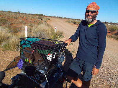
Met another interesting character on the road, a chap from Switzerland who came to Australia to push a shopping trolley full of his stuff from Darwin to Adelaide.  Very nice guy, but couldn't get away from him, he obviously was starved of people to talk to.  He told me that since he started that he met about 30 cyclists doing the route.  Considering how much earlier he would have had to start, this is probably the number riding the Stuart Highway this year.  The majority would have been going from Darwin to Adelaide or vice-versa, I wonder what percentage were Japanese?


I really suffered from the day before (and probably from the whole week of silly daily distances). The last 15km into Port Augusta was straight into a stiff headwind, a cruel sting in the tail. However, I made it! Coast to coast, North to South through Australia in 19 days (including one rest day). It's now the home leg to Melbourne to go. Let's hope for a smooth journey back with some westerly winds.